You are here: Home > Network List > UW - Pacific Northwest Regional Seismic Network Stations List
> Station PASS Maple Falls, WA, USA > Earthquake Result Viewer
PASS Maple Falls, WA, USA - Earthquake Result Viewer
*The percent match for this event was below the threshold and hence no stack was calculated.
| Earthquake location: |
Hawaii |
| Earthquake latitude/longitude: |
18.8/-155.5 |
| Earthquake time(UTC): |
2021/10/10 (283) 21:48:36 GMT |
| Earthquake Depth: |
35 km |
| Earthquake Magnitude: |
6.2 Ml |
| Earthquake Catalog/Contributor: |
NEIC PDE/hv |
|
| Network: |
UW Pacific Northwest Regional Seismic Network |
| Station: |
PASS Maple Falls, WA, USA |
| Lat/Lon: |
49.00 N/122.09 W |
| Elevation: |
174 m |
|
| Distance: |
40.4 deg |
| Az: |
34.076 deg |
| Baz: |
233.69 deg |
| Ray Param: |
$rayparam |
*The percent match for this event was below the threshold and hence was not used in the summary stack. |
|
| Radial Match: |
71.33646 % |
| Radial Bump: |
400 |
| Transverse Match: |
65.38184 % |
| Transverse Bump: |
400 |
| SOD ConfigId: |
26497111 |
| Insert Time: |
2021-10-24 22:22:34.325 +0000 |
| GWidth: |
2.5 |
| Max Bumps: |
400 |
| Tol: |
0.001 |
|
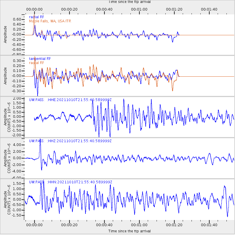
Signal To Noise
| Channel | StoN | STA | LTA |
| UW:PASS: :HHZ:20211010T21:55:40.589999Z | 6.8060875 | 1.9754082E-6 | 2.9024136E-7 |
| UW:PASS: :HHN:20211010T21:55:40.589999Z | 2.3229616 | 5.8200965E-7 | 2.5054638E-7 |
| UW:PASS: :HHE:20211010T21:55:40.589999Z | 2.637198 | 6.063834E-7 | 2.2993474E-7 |
| Arrivals |
| Ps | |
| PpPs | |
| PsPs/PpSs | |


