You are here: Home > Network List > UW - Pacific Northwest Regional Seismic Network Stations List
> Station WOLL Wollman Farm, Schrag, WA, USA > Earthquake Result Viewer
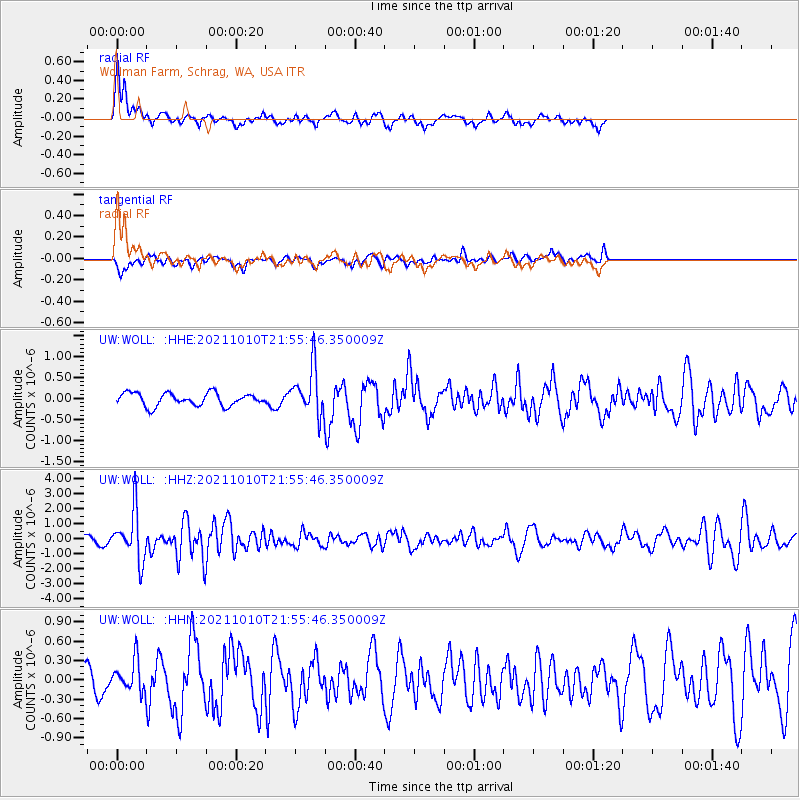
WOLL Wollman Farm, Schrag, WA, USA - Earthquake Result Viewer
*The percent match for this event was below the threshold and hence no stack was calculated.
| Earthquake location: |
Hawaii |
| Earthquake latitude/longitude: |
18.8/-155.5 |
| Earthquake time(UTC): |
2021/10/10 (283) 21:48:36 GMT |
| Earthquake Depth: |
35 km |
| Earthquake Magnitude: |
6.2 Ml |
| Earthquake Catalog/Contributor: |
NEIC PDE/hv |
|
| Network: |
UW Pacific Northwest Regional Seismic Network |
| Station: |
WOLL Wollman Farm, Schrag, WA, USA |
| Lat/Lon: |
47.06 N/118.92 W |
| Elevation: |
385 m |
|
| Distance: |
41.1 deg |
| Az: |
38.356 deg |
| Baz: |
239.28 deg |
| Ray Param: |
$rayparam |
*The percent match for this event was below the threshold and hence was not used in the summary stack. |
|
| Radial Match: |
67.831924 % |
| Radial Bump: |
400 |
| Transverse Match: |
52.282627 % |
| Transverse Bump: |
400 |
| SOD ConfigId: |
26497111 |
| Insert Time: |
2021-10-24 22:23:13.045 +0000 |
| GWidth: |
2.5 |
| Max Bumps: |
400 |
| Tol: |
0.001 |
|
Signal To Noise
| Channel | StoN | STA | LTA |
| UW:WOLL: :HHZ:20211010T21:55:46.350009Z | 8.455011 | 1.6326114E-6 | 1.9309394E-7 |
| UW:WOLL: :HHN:20211010T21:55:46.350009Z | 0.9343303 | 2.3542863E-7 | 2.519758E-7 |
| UW:WOLL: :HHE:20211010T21:55:46.350009Z | 3.7273567 | 5.674256E-7 | 1.522327E-7 |
| Arrivals |
| Ps | |
| PpPs | |
| PsPs/PpSs | |


