You are here: Home > Network List > AE - Arizona Broadband Seismic Network Stations List
> Station PRCT Prescott > Earthquake Result Viewer
PRCT Prescott - Earthquake Result Viewer
| Earthquake location: |
Alaska Peninsula |
| Earthquake latitude/longitude: |
56.3/-156.6 |
| Earthquake time(UTC): |
2021/10/11 (284) 09:10:24 GMT |
| Earthquake Depth: |
69 km |
| Earthquake Magnitude: |
6.9 mww |
| Earthquake Catalog/Contributor: |
NEIC PDE/ak |
|
| Network: |
AE Arizona Broadband Seismic Network |
| Station: |
PRCT Prescott |
| Lat/Lon: |
35.06 N/112.71 W |
| Elevation: |
1410 m |
|
| Distance: |
36.4 deg |
| Az: |
106.834 deg |
| Baz: |
319.38 deg |
| Ray Param: |
0.07651817 |
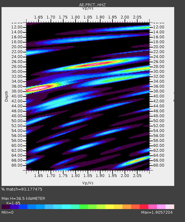
| Estimated Moho Depth: |
36.5 km |
| Estimated Crust Vp/Vs: |
1.65 |
| Assumed Crust Vp: |
6.276 km/s |
| Estimated Crust Vs: |
3.804 km/s |
| Estimated Crust Poisson's Ratio: |
0.21 |
|
| Radial Match: |
93.177475 % |
| Radial Bump: |
400 |
| Transverse Match: |
79.92803 % |
| Transverse Bump: |
400 |
| SOD ConfigId: |
26497111 |
| Insert Time: |
2021-10-25 09:11:30.579 +0000 |
| GWidth: |
2.5 |
| Max Bumps: |
400 |
| Tol: |
0.001 |
|

Signal To Noise
| Channel | StoN | STA | LTA |
| AE:PRCT: :HHZ:20211011T09:16:52.278985Z | 10.155629 | 1.5961224E-6 | 1.5716628E-7 |
| AE:PRCT: :HHN:20211011T09:16:52.278985Z | 2.2914703 | 4.2954903E-7 | 1.8745565E-7 |
| AE:PRCT: :HHE:20211011T09:16:52.278985Z | 2.7123127 | 5.0245427E-7 | 1.8524938E-7 |
| Arrivals |
| Ps | 4.1 SECOND |
| PpPs | 14 SECOND |
| PsPs/PpSs | 18 SECOND |


