You are here: Home > Network List > AG - Arkansas Seismic Network Stations List
> Station X40A Basin Creek Farm, Marlvern, AR > Earthquake Result Viewer
X40A Basin Creek Farm, Marlvern, AR - Earthquake Result Viewer
| Earthquake location: |
Alaska Peninsula |
| Earthquake latitude/longitude: |
56.3/-156.6 |
| Earthquake time(UTC): |
2021/10/11 (284) 09:10:24 GMT |
| Earthquake Depth: |
69 km |
| Earthquake Magnitude: |
6.9 mww |
| Earthquake Catalog/Contributor: |
NEIC PDE/ak |
|
| Network: |
AG Arkansas Seismic Network |
| Station: |
X40A Basin Creek Farm, Marlvern, AR |
| Lat/Lon: |
34.49 N/92.83 W |
| Elevation: |
158 m |
|
| Distance: |
47.8 deg |
| Az: |
89.147 deg |
| Baz: |
317.508 deg |
| Ray Param: |
0.06957849 |
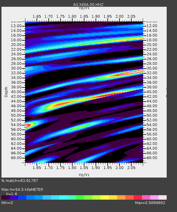
| Estimated Moho Depth: |
54.5 km |
| Estimated Crust Vp/Vs: |
1.60 |
| Assumed Crust Vp: |
6.498 km/s |
| Estimated Crust Vs: |
4.061 km/s |
| Estimated Crust Poisson's Ratio: |
0.18 |
|
| Radial Match: |
93.91797 % |
| Radial Bump: |
351 |
| Transverse Match: |
70.8085 % |
| Transverse Bump: |
400 |
| SOD ConfigId: |
26497111 |
| Insert Time: |
2021-10-25 09:11:49.157 +0000 |
| GWidth: |
2.5 |
| Max Bumps: |
400 |
| Tol: |
0.001 |
|
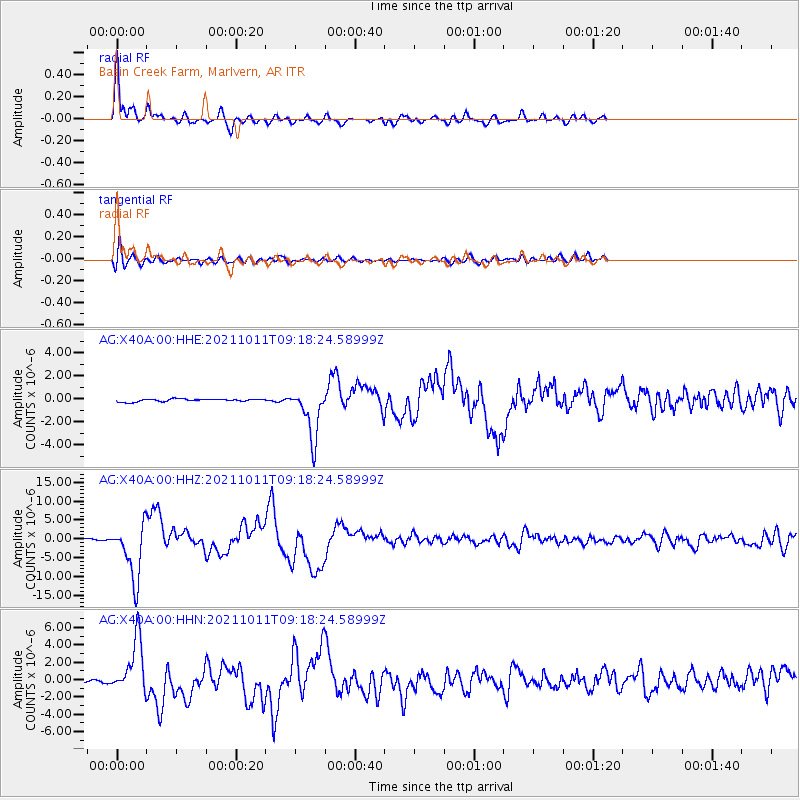
Signal To Noise
| Channel | StoN | STA | LTA |
| AG:X40A:00:HHZ:20211011T09:18:24.58999Z | 59.862015 | 7.4221475E-6 | 1.239876E-7 |
| AG:X40A:00:HHN:20211011T09:18:24.58999Z | 19.018957 | 3.1379577E-6 | 1.6499105E-7 |
| AG:X40A:00:HHE:20211011T09:18:24.58999Z | 18.80405 | 2.1769567E-6 | 1.1577063E-7 |
| Arrivals |
| Ps | 5.4 SECOND |
| PpPs | 20 SECOND |
| PsPs/PpSs | 26 SECOND |


