You are here: Home > Network List > CA - Catalan Seismic Network Stations List
> Station CBRU Bruguera > Earthquake Result Viewer
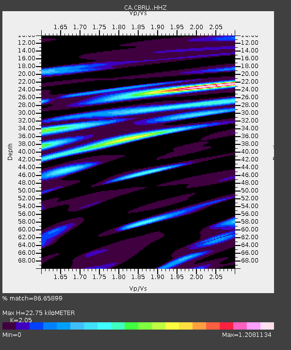
CBRU Bruguera - Earthquake Result Viewer
| Earthquake location: |
Alaska Peninsula |
| Earthquake latitude/longitude: |
56.3/-156.6 |
| Earthquake time(UTC): |
2021/10/11 (284) 09:10:24 GMT |
| Earthquake Depth: |
69 km |
| Earthquake Magnitude: |
6.9 mww |
| Earthquake Catalog/Contributor: |
NEIC PDE/ak |
|
| Network: |
CA Catalan Seismic Network |
| Station: |
CBRU Bruguera |
| Lat/Lon: |
42.28 N/2.18 E |
| Elevation: |
1327 m |
|
| Distance: |
80.2 deg |
| Az: |
15.852 deg |
| Baz: |
348.146 deg |
| Ray Param: |
0.048309915 |
| Estimated Moho Depth: |
22.75 km |
| Estimated Crust Vp/Vs: |
2.05 |
| Assumed Crust Vp: |
6.264 km/s |
| Estimated Crust Vs: |
3.055 km/s |
| Estimated Crust Poisson's Ratio: |
0.34 |
|
| Radial Match: |
86.65899 % |
| Radial Bump: |
400 |
| Transverse Match: |
83.33668 % |
| Transverse Bump: |
400 |
| SOD ConfigId: |
26497111 |
| Insert Time: |
2021-10-25 09:13:07.098 +0000 |
| GWidth: |
2.5 |
| Max Bumps: |
400 |
| Tol: |
0.001 |
|

Signal To Noise
| Channel | StoN | STA | LTA |
| CA:CBRU: :HHZ:20211011T09:21:56.520013Z | 13.60133 | 3.2122643E-6 | 2.3617281E-7 |
| CA:CBRU: :HHN:20211011T09:21:56.520013Z | 4.704653 | 1.0258369E-6 | 2.1804733E-7 |
| CA:CBRU: :HHE:20211011T09:21:56.520013Z | 2.0623753 | 3.873737E-7 | 1.8782889E-7 |
| Arrivals |
| Ps | 3.9 SECOND |
| PpPs | 11 SECOND |
| PsPs/PpSs | 15 SECOND |


