You are here: Home > Network List > CA - Catalan Seismic Network Stations List
> Station CPAL Palau-saverdera > Earthquake Result Viewer
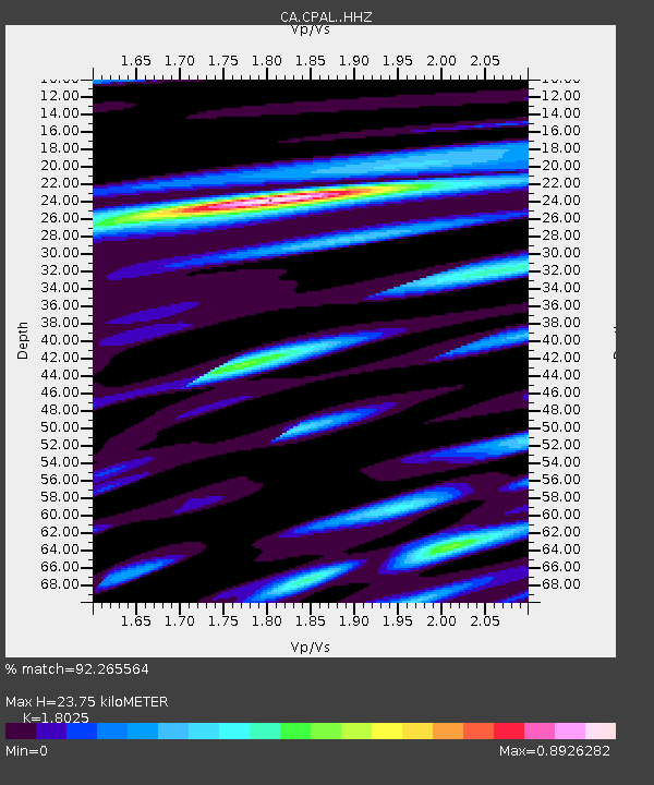
CPAL Palau-saverdera - Earthquake Result Viewer
| Earthquake location: |
Alaska Peninsula |
| Earthquake latitude/longitude: |
56.3/-156.6 |
| Earthquake time(UTC): |
2021/10/11 (284) 09:10:24 GMT |
| Earthquake Depth: |
69 km |
| Earthquake Magnitude: |
6.9 mww |
| Earthquake Catalog/Contributor: |
NEIC PDE/ak |
|
| Network: |
CA Catalan Seismic Network |
| Station: |
CPAL Palau-saverdera |
| Lat/Lon: |
42.31 N/3.16 E |
| Elevation: |
212 m |
|
| Distance: |
80.3 deg |
| Az: |
15.122 deg |
| Baz: |
348.682 deg |
| Ray Param: |
0.048225056 |
| Estimated Moho Depth: |
23.75 km |
| Estimated Crust Vp/Vs: |
1.80 |
| Assumed Crust Vp: |
6.264 km/s |
| Estimated Crust Vs: |
3.475 km/s |
| Estimated Crust Poisson's Ratio: |
0.28 |
|
| Radial Match: |
92.265564 % |
| Radial Bump: |
376 |
| Transverse Match: |
80.21519 % |
| Transverse Bump: |
400 |
| SOD ConfigId: |
26497111 |
| Insert Time: |
2021-10-25 09:13:19.112 +0000 |
| GWidth: |
2.5 |
| Max Bumps: |
400 |
| Tol: |
0.001 |
|

Signal To Noise
| Channel | StoN | STA | LTA |
| CA:CPAL: :HHZ:20211011T09:21:57.160027Z | 13.159202 | 3.6409658E-6 | 2.766859E-7 |
| CA:CPAL: :HHN:20211011T09:21:57.160027Z | 9.003869 | 1.3683031E-6 | 1.5196835E-7 |
| CA:CPAL: :HHE:20211011T09:21:57.160027Z | 3.6970062 | 6.116335E-7 | 1.654402E-7 |
| Arrivals |
| Ps | 3.1 SECOND |
| PpPs | 10 SECOND |
| PsPs/PpSs | 13 SECOND |


