You are here: Home > Network List > CI - Caltech Regional Seismic Network Stations List
> Station LRL Laurel Mtn Radio Fac, Ridgecrest, CA, USA > Earthquake Result Viewer
LRL Laurel Mtn Radio Fac, Ridgecrest, CA, USA - Earthquake Result Viewer

| Earthquake location: |
Alaska Peninsula |
| Earthquake latitude/longitude: |
56.3/-156.6 |
| Earthquake time(UTC): |
2021/10/11 (284) 09:10:24 GMT |
| Earthquake Depth: |
69 km |
| Earthquake Magnitude: |
6.9 mww |
| Earthquake Catalog/Contributor: |
NEIC PDE/ak |
|
| Network: |
CI Caltech Regional Seismic Network |
| Station: |
LRL Laurel Mtn Radio Fac, Ridgecrest, CA, USA |
| Lat/Lon: |
35.48 N/117.68 W |
| Elevation: |
1340 m |
|
| Distance: |
33.5 deg |
| Az: |
111.798 deg |
| Baz: |
320.592 deg |
| Ray Param: |
0.07802884 |
| Estimated Moho Depth: |
21.5 km |
| Estimated Crust Vp/Vs: |
2.10 |
| Assumed Crust Vp: |
6.276 km/s |
| Estimated Crust Vs: |
2.992 km/s |
| Estimated Crust Poisson's Ratio: |
0.35 |
|
| Radial Match: |
91.60809 % |
| Radial Bump: |
344 |
| Transverse Match: |
78.80658 % |
| Transverse Bump: |
400 |
| SOD ConfigId: |
26497111 |
| Insert Time: |
2021-10-25 09:14:32.498 +0000 |
| GWidth: |
2.5 |
| Max Bumps: |
400 |
| Tol: |
0.001 |
|
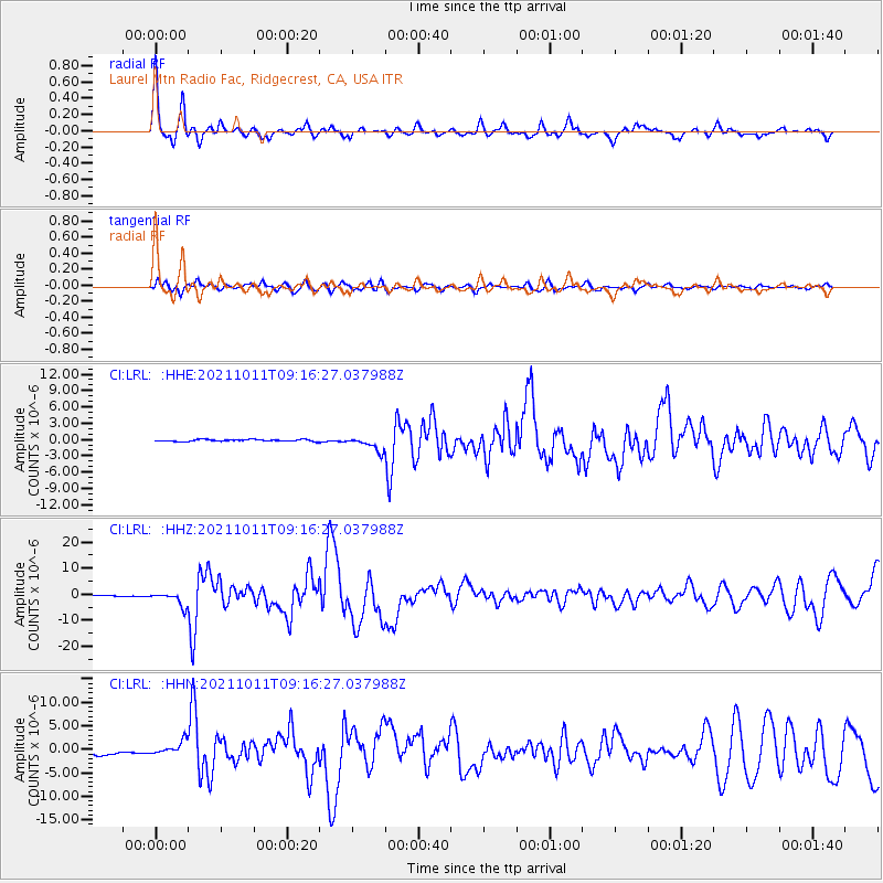
Signal To Noise
| Channel | StoN | STA | LTA |
| CI:LRL: :HHZ:20211011T09:16:27.037988Z | 16.65461 | 2.5789777E-6 | 1.5485068E-7 |
| CI:LRL: :HHN:20211011T09:16:27.037988Z | 3.2626138 | 1.5279587E-6 | 4.683235E-7 |
| CI:LRL: :HHE:20211011T09:16:27.037988Z | 7.5828624 | 1.308854E-6 | 1.7260686E-7 |
| Arrivals |
| Ps | 4.0 SECOND |
| PpPs | 10.0 SECOND |
| PsPs/PpSs | 14 SECOND |


