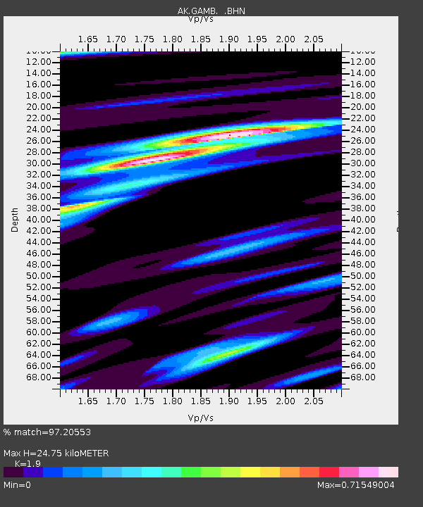
GAMB Gambell Broadband - Earthquake Result Viewer
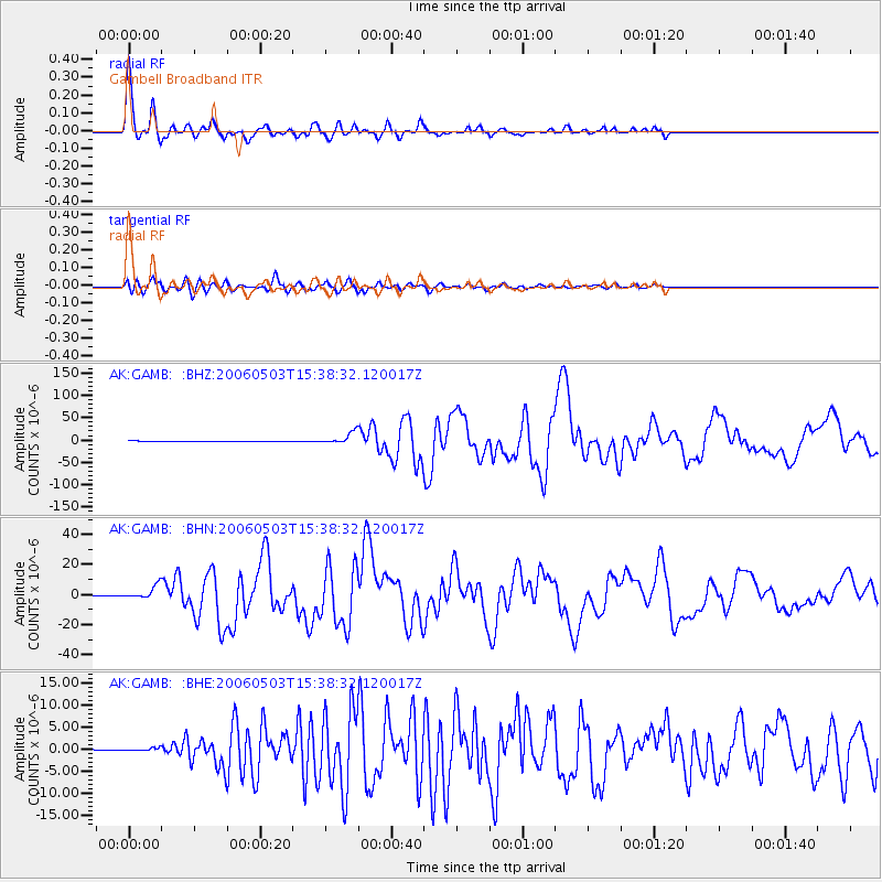
Earthquake location: Tonga Islands
Earthquake latitude/longitude: -20.2/-174.1
Earthquake time(UTC): 2006/05/03 (123) 15:26:40 GMT
Earthquake Depth: 55 km
Earthquake Magnitude: 7.2 MB, 7.8 MS, 7.9 MW, 7.9 MW
Earthquake Catalog/Contributor: WHDF/NEIC
Network: AK Alaska Regional Network
Station: GAMB Gambell Broadband
Lat/Lon: 63.78 N/171.70 W
Elevation: 10 m
Distance: 83.7 deg
Az: 1.082 deg
Baz: 182.289 deg
Ray Param: 0.045896083
Estimated Moho Depth: 24.75 km
Estimated Crust Vp/Vs: 1.90
Assumed Crust Vp: 6.24 km/s
Estimated Crust Vs: 3.284 km/s
Estimated Crust Poisson's Ratio: 0.31
Radial Match: 97.20553 %
Radial Bump: 349
Transverse Match: 90.979706 %
Transverse Bump: 400
SOD ConfigId: 2669
Insert Time: 2010-03-09 13:40:38.296 +0000
GWidth: 2.5
Max Bumps: 400
Tol: 0.001

Signal To Noise

ChannelStoNSTALTA
AK:GAMB: :BHN:20060503T15:38:32.120017Z29.6674564.1536914E-61.4000835E-7
AK:GAMB: :BHE:20060503T15:38:32.120017Z1.78635615.832668E-73.2651204E-7
AK:GAMB: :BHZ:20060503T15:38:32.120017Z34.1046641.2653211E-53.710112E-7
Arrivals
Ps3.6 SECOND
PpPs11 SECOND
PsPs/PpSs15 SECOND