You are here: Home > Network List > CN - Canadian National Seismograph Network Stations List
> Station A54 Misere, QC, CA > Earthquake Result Viewer
A54 Misere, QC, CA - Earthquake Result Viewer
| Earthquake location: |
Alaska Peninsula |
| Earthquake latitude/longitude: |
56.3/-156.6 |
| Earthquake time(UTC): |
2021/10/11 (284) 09:10:24 GMT |
| Earthquake Depth: |
69 km |
| Earthquake Magnitude: |
6.9 mww |
| Earthquake Catalog/Contributor: |
NEIC PDE/ak |
|
| Network: |
CN Canadian National Seismograph Network |
| Station: |
A54 Misere, QC, CA |
| Lat/Lon: |
47.46 N/70.41 W |
| Elevation: |
377 m |
|
| Distance: |
50.6 deg |
| Az: |
61.217 deg |
| Baz: |
313.886 deg |
| Ray Param: |
0.06775815 |
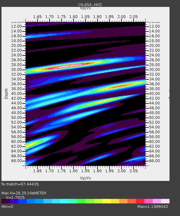
| Estimated Moho Depth: |
28.25 km |
| Estimated Crust Vp/Vs: |
1.78 |
| Assumed Crust Vp: |
6.61 km/s |
| Estimated Crust Vs: |
3.708 km/s |
| Estimated Crust Poisson's Ratio: |
0.27 |
|
| Radial Match: |
87.44435 % |
| Radial Bump: |
400 |
| Transverse Match: |
76.43721 % |
| Transverse Bump: |
400 |
| SOD ConfigId: |
26497111 |
| Insert Time: |
2021-10-25 09:15:37.218 +0000 |
| GWidth: |
2.5 |
| Max Bumps: |
400 |
| Tol: |
0.001 |
|

Signal To Noise
| Channel | StoN | STA | LTA |
| CN:A54: :HHZ:20211011T09:18:45.83001Z | 22.072676 | 6.6984667E-6 | 3.0347326E-7 |
| CN:A54: :HHN:20211011T09:18:45.83001Z | 6.811739 | 2.0696925E-6 | 3.03842E-7 |
| CN:A54: :HHE:20211011T09:18:45.83001Z | 10.399396 | 3.0484728E-6 | 2.931394E-7 |
| Arrivals |
| Ps | 3.6 SECOND |
| PpPs | 11 SECOND |
| PsPs/PpSs | 15 SECOND |


