You are here: Home > Network List > AK - Alaska Regional Network Stations List
> Station GAMB Gambell Broadband > Earthquake Result Viewer
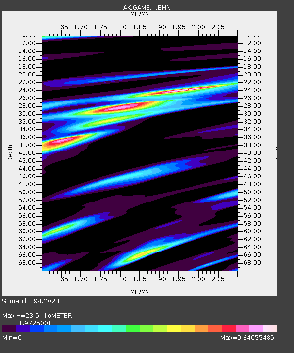
GAMB Gambell Broadband - Earthquake Result Viewer
| Earthquake location: |
Tonga Islands |
| Earthquake latitude/longitude: |
-16.8/-174.2 |
| Earthquake time(UTC): |
2004/01/25 (025) 11:43:11 GMT |
| Earthquake Depth: |
130 km |
| Earthquake Magnitude: |
6.4 MB, 6.7 MW, 6.7 MW |
| Earthquake Catalog/Contributor: |
WHDF/NEIC |
|
| Network: |
AK Alaska Regional Network |
| Station: |
GAMB Gambell Broadband |
| Lat/Lon: |
63.78 N/171.70 W |
| Elevation: |
10 m |
|
| Distance: |
80.4 deg |
| Az: |
1.124 deg |
| Baz: |
182.424 deg |
| Ray Param: |
0.048024833 |
| Estimated Moho Depth: |
23.5 km |
| Estimated Crust Vp/Vs: |
1.97 |
| Assumed Crust Vp: |
6.24 km/s |
| Estimated Crust Vs: |
3.163 km/s |
| Estimated Crust Poisson's Ratio: |
0.33 |
|
| Radial Match: |
94.20231 % |
| Radial Bump: |
290 |
| Transverse Match: |
72.26141 % |
| Transverse Bump: |
400 |
| SOD ConfigId: |
263228 |
| Insert Time: |
2010-03-09 13:40:42.054 +0000 |
| GWidth: |
2.5 |
| Max Bumps: |
400 |
| Tol: |
0.001 |
|

Signal To Noise
| Channel | StoN | STA | LTA |
| AK:GAMB: :BHN:20040125T11:54:37.739019Z | 19.108078 | 3.0999734E-6 | 1.6223365E-7 |
| AK:GAMB: :BHE:20040125T11:54:37.739019Z | 1.7801555 | 4.235673E-7 | 2.3793837E-7 |
| AK:GAMB: :BHZ:20040125T11:54:37.739019Z | 38.435608 | 7.1854615E-6 | 1.8694803E-7 |
| Arrivals |
| Ps | 3.7 SECOND |
| PpPs | 11 SECOND |
| PsPs/PpSs | 15 SECOND |


