You are here: Home > Network List > AK - Alaska Regional Network Stations List
> Station GAMB Gambell Broadband > Earthquake Result Viewer
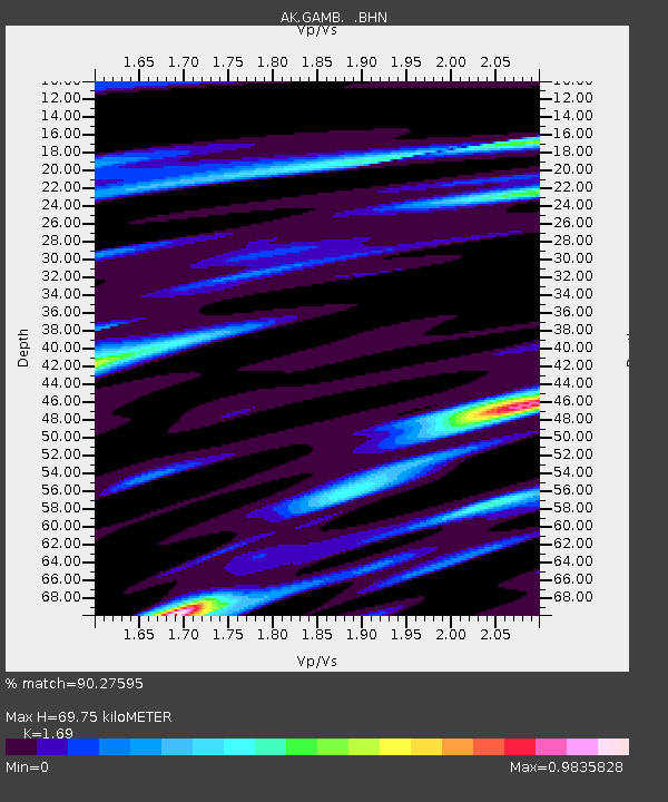
GAMB Gambell Broadband - Earthquake Result Viewer
| Earthquake location: |
Afghanistan-Tajikistan Bord Reg. |
| Earthquake latitude/longitude: |
36.4/71.1 |
| Earthquake time(UTC): |
2005/12/12 (346) 21:47:46 GMT |
| Earthquake Depth: |
225 km |
| Earthquake Magnitude: |
6.0 MB, 6.5 MW, 6.5 MW |
| Earthquake Catalog/Contributor: |
WHDF/NEIC |
|
| Network: |
AK Alaska Regional Network |
| Station: |
GAMB Gambell Broadband |
| Lat/Lon: |
63.78 N/171.70 W |
| Elevation: |
10 m |
|
| Distance: |
68.6 deg |
| Az: |
25.11 deg |
| Baz: |
309.55 deg |
| Ray Param: |
0.05554583 |
| Estimated Moho Depth: |
69.75 km |
| Estimated Crust Vp/Vs: |
1.69 |
| Assumed Crust Vp: |
6.24 km/s |
| Estimated Crust Vs: |
3.692 km/s |
| Estimated Crust Poisson's Ratio: |
0.23 |
|
| Radial Match: |
90.27595 % |
| Radial Bump: |
291 |
| Transverse Match: |
79.03812 % |
| Transverse Bump: |
381 |
| SOD ConfigId: |
2422 |
| Insert Time: |
2010-03-09 13:40:44.991 +0000 |
| GWidth: |
2.5 |
| Max Bumps: |
400 |
| Tol: |
0.001 |
|

Signal To Noise
| Channel | StoN | STA | LTA |
| AK:GAMB: :BHN:20051212T21:57:53.700005Z | 7.997197 | 1.6555803E-6 | 2.0702007E-7 |
| AK:GAMB: :BHE:20051212T21:57:53.700005Z | 5.550183 | 1.740064E-6 | 3.1351473E-7 |
| AK:GAMB: :BHZ:20051212T21:57:53.700005Z | 29.004105 | 4.6987097E-6 | 1.6200156E-7 |
| Arrivals |
| Ps | 8.0 SECOND |
| PpPs | 29 SECOND |
| PsPs/PpSs | 37 SECOND |


