GAMB Gambell Broadband - Earthquake Result Viewer
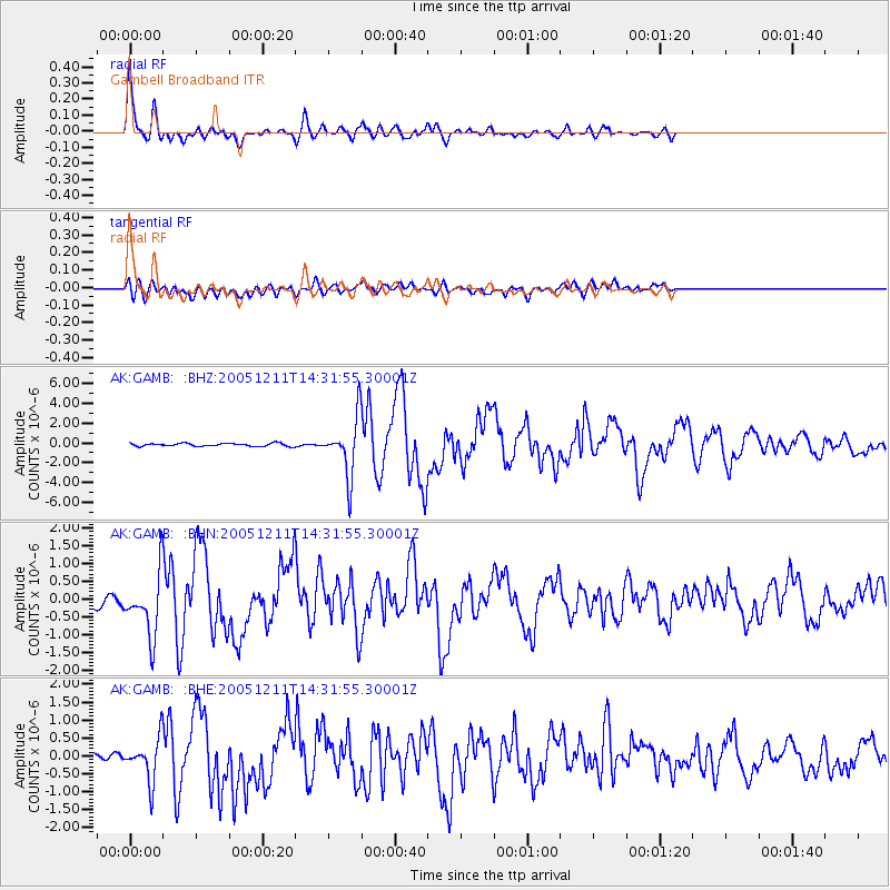
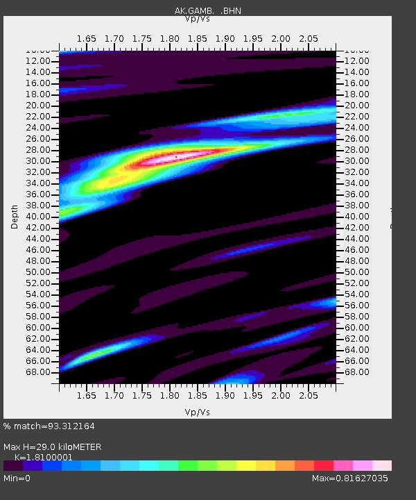
Earthquake location: New Britain Region, P.N.G.
Earthquake latitude/longitude: -6.6/152.2
Earthquake time(UTC): 2005/12/11 (345) 14:20:43 GMT
Earthquake Depth: 10 km
Earthquake Magnitude: 6.2 MB, 6.2 MS, 6.6 MW, 6.5 MW
Earthquake Catalog/Contributor: WHDF/NEIC
Network: AK Alaska Regional Network
Station: GAMB Gambell Broadband
Lat/Lon: 63.78 N/171.70 W
Elevation: 10 m
Distance: 75.2 deg
Az: 15.707 deg
Baz: 217.259 deg
Ray Param: 0.051803596
Estimated Moho Depth: 29.0 km
Estimated Crust Vp/Vs: 1.81
Assumed Crust Vp: 6.24 km/s
Estimated Crust Vs: 3.448 km/s
Estimated Crust Poisson's Ratio: 0.28
Radial Match: 93.312164 %
Radial Bump: 385
Transverse Match: 73.68294 %
Transverse Bump: 400
SOD ConfigId: 2422
Insert Time: 2010-03-09 13:40:45.930 +0000
GWidth: 2.5
Max Bumps: 400
Tol: 0.001

Signal To Noise

ChannelStoNSTALTA
AK:GAMB: :BHN:20051211T14:31:55.30001Z5.421688.630586E-71.5918656E-7
AK:GAMB: :BHE:20051211T14:31:55.30001Z2.84291035.849559E-72.0575953E-7
AK:GAMB: :BHZ:20051211T14:31:55.30001Z20.2197442.8788256E-61.4237696E-7
Arrivals
Ps3.9 SECOND
PpPs13 SECOND
PsPs/PpSs17 SECOND