You are here: Home > Network List > CN - Canadian National Seismograph Network Stations List
> Station LGNH LEOGANE, Haiti, > Earthquake Result Viewer
LGNH LEOGANE, Haiti, - Earthquake Result Viewer
| Earthquake location: |
Alaska Peninsula |
| Earthquake latitude/longitude: |
56.3/-156.6 |
| Earthquake time(UTC): |
2021/10/11 (284) 09:10:24 GMT |
| Earthquake Depth: |
69 km |
| Earthquake Magnitude: |
6.9 mww |
| Earthquake Catalog/Contributor: |
NEIC PDE/ak |
|
| Network: |
CN Canadian National Seismograph Network |
| Station: |
LGNH LEOGANE, Haiti, |
| Lat/Lon: |
18.51 N/72.61 W |
| Elevation: |
62 m |
|
| Distance: |
71.5 deg |
| Az: |
84.367 deg |
| Baz: |
324.18 deg |
| Ray Param: |
0.05415929 |
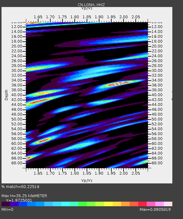
| Estimated Moho Depth: |
35.25 km |
| Estimated Crust Vp/Vs: |
1.97 |
| Assumed Crust Vp: |
5.14 km/s |
| Estimated Crust Vs: |
2.606 km/s |
| Estimated Crust Poisson's Ratio: |
0.33 |
|
| Radial Match: |
80.22516 % |
| Radial Bump: |
400 |
| Transverse Match: |
82.63354 % |
| Transverse Bump: |
400 |
| SOD ConfigId: |
26497111 |
| Insert Time: |
2021-10-25 09:16:21.355 +0000 |
| GWidth: |
2.5 |
| Max Bumps: |
400 |
| Tol: |
0.001 |
|

Signal To Noise
| Channel | StoN | STA | LTA |
| CN:LGNH: :HHZ:20211011T09:21:07.020013Z | 54.618145 | 9.449436E-6 | 1.7300911E-7 |
| CN:LGNH: :HHN:20211011T09:21:07.020013Z | 9.3945265 | 1.7439002E-6 | 1.8562939E-7 |
| CN:LGNH: :HHE:20211011T09:21:07.020013Z | 11.926593 | 2.1313188E-6 | 1.7870308E-7 |
| Arrivals |
| Ps | 6.8 SECOND |
| PpPs | 20 SECOND |
| PsPs/PpSs | 27 SECOND |


