You are here: Home > Network List > CN - Canadian National Seismograph Network Stations List
> Station SADO Sadowa, ON, CA > Earthquake Result Viewer
SADO Sadowa, ON, CA - Earthquake Result Viewer
| Earthquake location: |
Alaska Peninsula |
| Earthquake latitude/longitude: |
56.3/-156.6 |
| Earthquake time(UTC): |
2021/10/11 (284) 09:10:24 GMT |
| Earthquake Depth: |
69 km |
| Earthquake Magnitude: |
6.9 mww |
| Earthquake Catalog/Contributor: |
NEIC PDE/ak |
|
| Network: |
CN Canadian National Seismograph Network |
| Station: |
SADO Sadowa, ON, CA |
| Lat/Lon: |
44.77 N/79.14 W |
| Elevation: |
228 m |
|
| Distance: |
48.0 deg |
| Az: |
69.289 deg |
| Baz: |
312.88 deg |
| Ray Param: |
0.069437884 |
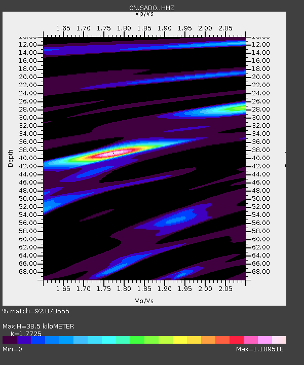
| Estimated Moho Depth: |
38.5 km |
| Estimated Crust Vp/Vs: |
1.77 |
| Assumed Crust Vp: |
6.577 km/s |
| Estimated Crust Vs: |
3.711 km/s |
| Estimated Crust Poisson's Ratio: |
0.27 |
|
| Radial Match: |
92.878555 % |
| Radial Bump: |
238 |
| Transverse Match: |
85.176414 % |
| Transverse Bump: |
303 |
| SOD ConfigId: |
26497111 |
| Insert Time: |
2021-10-25 09:16:36.679 +0000 |
| GWidth: |
2.5 |
| Max Bumps: |
400 |
| Tol: |
0.001 |
|

Signal To Noise
| Channel | StoN | STA | LTA |
| CN:SADO: :HHZ:20211011T09:18:26.240014Z | 32.42827 | 9.147516E-6 | 2.820846E-7 |
| CN:SADO: :HHN:20211011T09:18:26.240014Z | 34.55688 | 4.890339E-6 | 1.4151564E-7 |
| CN:SADO: :HHE:20211011T09:18:26.240014Z | 12.396052 | 2.4867438E-6 | 2.0060773E-7 |
| Arrivals |
| Ps | 4.8 SECOND |
| PpPs | 15 SECOND |
| PsPs/PpSs | 20 SECOND |


