GAMB Gambell Broadband - Earthquake Result Viewer
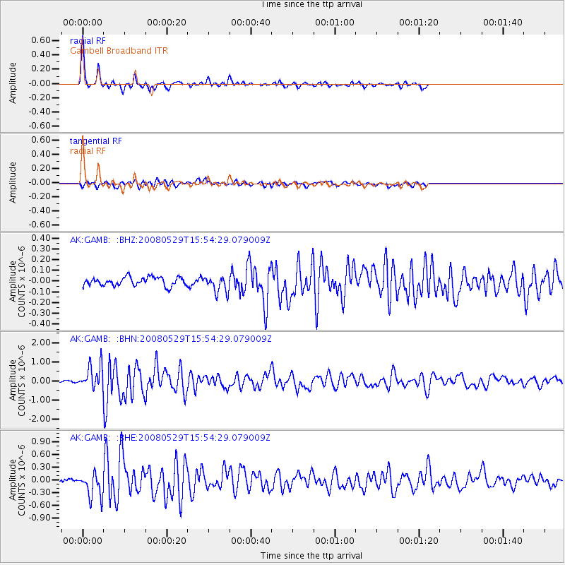
Earthquake location: Iceland
Earthquake latitude/longitude: 64.0/-21.0
Earthquake time(UTC): 2008/05/29 (150) 15:46:00 GMT
Earthquake Depth: 10 km
Earthquake Magnitude: 6.0 MB, 6.2 MS, 6.3 MW, 6.2 MW
Earthquake Catalog/Contributor: WHDF/NEIC
Network: AK Alaska Regional Network
Station: GAMB Gambell Broadband
Lat/Lon: 63.78 N/171.70 W
Elevation: 10 m
Distance: 50.7 deg
Az: 343.675 deg
Baz: 16.19 deg
Ray Param: 0.067885794
Estimated Moho Depth: 29.75 km
Estimated Crust Vp/Vs: 1.75
Assumed Crust Vp: 6.24 km/s
Estimated Crust Vs: 3.556 km/s
Estimated Crust Poisson's Ratio: 0.26
Radial Match: 90.84067 %
Radial Bump: 286
Transverse Match: 75.14634 %
Transverse Bump: 400
SOD ConfigId: 2504
Insert Time: 2010-03-09 13:40:50.422 +0000
GWidth: 2.5
Max Bumps: 400
Tol: 0.001

Signal To Noise

ChannelStoNSTALTA
AK:GAMB: :BHN:20080529T15:54:29.079009Z8.0893156.320782E-77.813742E-8
AK:GAMB: :BHE:20080529T15:54:29.079009Z5.29580073.062751E-75.783358E-8
AK:GAMB: :BHZ:20080529T15:54:29.079009Z2.00640137.9705856E-83.972578E-8
Arrivals
Ps3.8 SECOND
PpPs12 SECOND
PsPs/PpSs16 SECOND