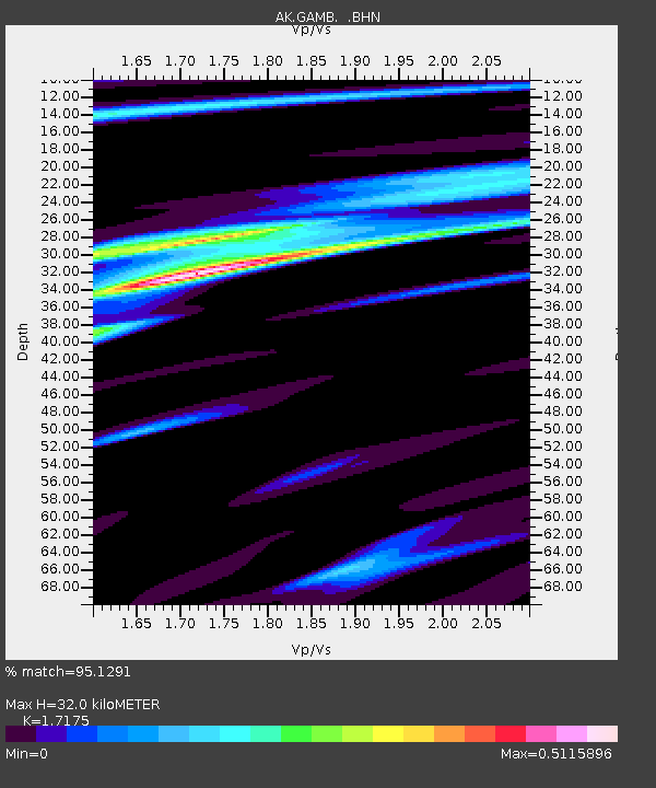
GAMB Gambell Broadband - Earthquake Result Viewer
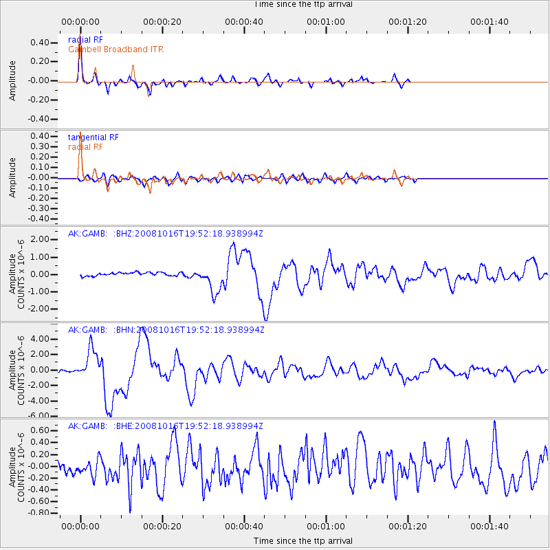
Earthquake location: Near Coast Of Chiapas, Mexico
Earthquake latitude/longitude: 14.4/-92.4
Earthquake time(UTC): 2008/10/16 (290) 19:41:25 GMT
Earthquake Depth: 24 km
Earthquake Magnitude: 6.1 MB, 6.6 MS, 6.7 MW, 6.6 MW
Earthquake Catalog/Contributor: WHDF/NEIC
Network: AK Alaska Regional Network
Station: GAMB Gambell Broadband
Lat/Lon: 63.78 N/171.70 W
Elevation: 10 m
Distance: 72.5 deg
Az: 332.749 deg
Baz: 93.045 deg
Ray Param: 0.053618208
Estimated Moho Depth: 32.0 km
Estimated Crust Vp/Vs: 1.72
Assumed Crust Vp: 6.24 km/s
Estimated Crust Vs: 3.633 km/s
Estimated Crust Poisson's Ratio: 0.24
Radial Match: 95.1291 %
Radial Bump: 296
Transverse Match: 68.46587 %
Transverse Bump: 400
SOD ConfigId: 2556
Insert Time: 2010-03-09 13:40:56.731 +0000
GWidth: 2.5
Max Bumps: 400
Tol: 0.001

Signal To Noise

ChannelStoNSTALTA
AK:GAMB: :BHN:20081016T19:52:18.938994Z16.7336142.0334594E-61.2151943E-7
AK:GAMB: :BHE:20081016T19:52:18.938994Z1.29471971.4565003E-71.12495414E-7
AK:GAMB: :BHZ:20081016T19:52:18.938994Z8.9533978.241325E-79.204691E-8
Arrivals
Ps3.8 SECOND
PpPs13 SECOND
PsPs/PpSs17 SECOND