You are here: Home > Network List > AK - Alaska Regional Network Stations List
> Station GAMB Gambell Broadband > Earthquake Result Viewer
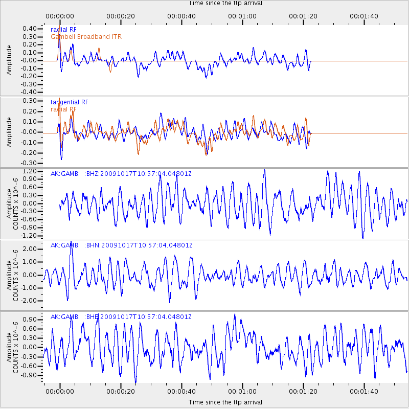
GAMB Gambell Broadband - Earthquake Result Viewer
*The percent match for this event was below the threshold and hence no stack was calculated.
| Earthquake location: |
Samoa Islands Region |
| Earthquake latitude/longitude: |
-16.4/-172.0 |
| Earthquake time(UTC): |
2009/10/17 (290) 10:45:26 GMT |
| Earthquake Depth: |
10 km |
| Earthquake Magnitude: |
5.7 MB, 5.3 MS, 5.7 MW, 5.7 MW |
| Earthquake Catalog/Contributor: |
WHDF/NEIC |
|
| Network: |
AK Alaska Regional Network |
| Station: |
GAMB Gambell Broadband |
| Lat/Lon: |
63.78 N/171.70 W |
| Elevation: |
10 m |
|
| Distance: |
79.9 deg |
| Az: |
0.129 deg |
| Baz: |
180.279 deg |
| Ray Param: |
$rayparam |
*The percent match for this event was below the threshold and hence was not used in the summary stack. |
|
| Radial Match: |
45.161964 % |
| Radial Bump: |
400 |
| Transverse Match: |
62.870514 % |
| Transverse Bump: |
400 |
| SOD ConfigId: |
2622 |
| Insert Time: |
2010-03-09 13:40:59.326 +0000 |
| GWidth: |
2.5 |
| Max Bumps: |
400 |
| Tol: |
0.001 |
|
Signal To Noise
| Channel | StoN | STA | LTA |
| AK:GAMB: :BHN:20091017T10:57:04.04801Z | 2.6973145 | 1.1416266E-6 | 4.2324567E-7 |
| AK:GAMB: :BHE:20091017T10:57:04.04801Z | 1.371645 | 4.6347336E-7 | 3.37896E-7 |
| AK:GAMB: :BHZ:20091017T10:57:04.04801Z | 1.7497576 | 5.5250115E-7 | 3.1575868E-7 |
| Arrivals |
| Ps | |
| PpPs | |
| PsPs/PpSs | |


