You are here: Home > Network List > G - GEOSCOPE Stations List
> Station FDFM Morne la Rosette, Martinique, France > Earthquake Result Viewer
FDFM Morne la Rosette, Martinique, France - Earthquake Result Viewer
| Earthquake location: |
Alaska Peninsula |
| Earthquake latitude/longitude: |
56.3/-156.6 |
| Earthquake time(UTC): |
2021/10/11 (284) 09:10:24 GMT |
| Earthquake Depth: |
69 km |
| Earthquake Magnitude: |
6.9 mww |
| Earthquake Catalog/Contributor: |
NEIC PDE/ak |
|
| Network: |
G GEOSCOPE |
| Station: |
FDFM Morne la Rosette, Martinique, France |
| Lat/Lon: |
14.73 N/61.16 W |
| Elevation: |
320 m |
|
| Distance: |
80.9 deg |
| Az: |
77.332 deg |
| Baz: |
325.756 deg |
| Ray Param: |
0.047861435 |
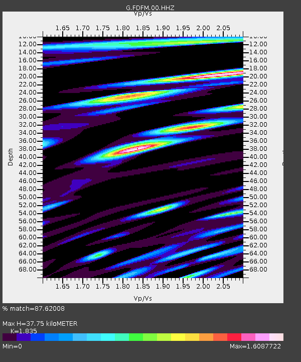
| Estimated Moho Depth: |
37.75 km |
| Estimated Crust Vp/Vs: |
1.84 |
| Assumed Crust Vp: |
5.88 km/s |
| Estimated Crust Vs: |
3.205 km/s |
| Estimated Crust Poisson's Ratio: |
0.29 |
|
| Radial Match: |
87.62008 % |
| Radial Bump: |
400 |
| Transverse Match: |
92.23992 % |
| Transverse Bump: |
400 |
| SOD ConfigId: |
26497111 |
| Insert Time: |
2021-10-25 09:18:25.350 +0000 |
| GWidth: |
2.5 |
| Max Bumps: |
400 |
| Tol: |
0.001 |
|

Signal To Noise
| Channel | StoN | STA | LTA |
| G:FDFM:00:HHZ:20211011T09:22:00.039971Z | 15.496357 | 7.134967E-6 | 4.6042868E-7 |
| G:FDFM:00:HHN:20211011T09:22:00.039971Z | 3.5832038 | 2.2391437E-6 | 6.248999E-7 |
| G:FDFM:00:HHE:20211011T09:22:00.039971Z | 2.713549 | 1.8759698E-6 | 6.9133444E-7 |
| Arrivals |
| Ps | 5.5 SECOND |
| PpPs | 18 SECOND |
| PsPs/PpSs | 23 SECOND |


