You are here: Home > Network List > G - GEOSCOPE Stations List
> Station HDC Heredia, Costa Rica > Earthquake Result Viewer
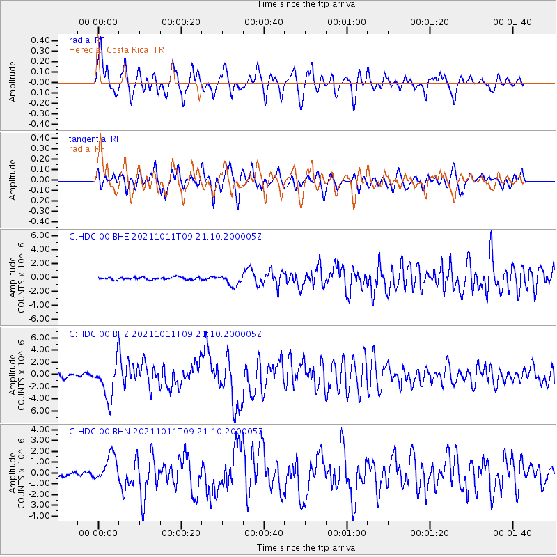
HDC Heredia, Costa Rica - Earthquake Result Viewer

| Earthquake location: |
Alaska Peninsula |
| Earthquake latitude/longitude: |
56.3/-156.6 |
| Earthquake time(UTC): |
2021/10/11 (284) 09:10:24 GMT |
| Earthquake Depth: |
69 km |
| Earthquake Magnitude: |
6.9 mww |
| Earthquake Catalog/Contributor: |
NEIC PDE/ak |
|
| Network: |
G GEOSCOPE |
| Station: |
HDC Heredia, Costa Rica |
| Lat/Lon: |
10.00 N/84.11 W |
| Elevation: |
1154 m |
|
| Distance: |
72.0 deg |
| Az: |
99.093 deg |
| Baz: |
325.985 deg |
| Ray Param: |
0.05380361 |
| Estimated Moho Depth: |
16.0 km |
| Estimated Crust Vp/Vs: |
1.75 |
| Assumed Crust Vp: |
6.597 km/s |
| Estimated Crust Vs: |
3.759 km/s |
| Estimated Crust Poisson's Ratio: |
0.26 |
|
| Radial Match: |
84.87017 % |
| Radial Bump: |
400 |
| Transverse Match: |
70.67156 % |
| Transverse Bump: |
400 |
| SOD ConfigId: |
26497111 |
| Insert Time: |
2021-10-25 09:18:28.425 +0000 |
| GWidth: |
2.5 |
| Max Bumps: |
400 |
| Tol: |
0.001 |
|
Signal To Noise
| Channel | StoN | STA | LTA |
| G:HDC:00:BHZ:20211011T09:21:10.200005Z | 14.250699 | 3.1864324E-6 | 2.235983E-7 |
| G:HDC:00:BHN:20211011T09:21:10.200005Z | 6.5442853 | 1.2937475E-6 | 1.9769116E-7 |
| G:HDC:00:BHE:20211011T09:21:10.200005Z | 5.00934 | 7.994292E-7 | 1.5958773E-7 |
| Arrivals |
| Ps | 1.9 SECOND |
| PpPs | 6.4 SECOND |
| PsPs/PpSs | 8.3 SECOND |


