You are here: Home > Network List > GM - US Geological Survey Networks Stations List
> Station NMP23 New Mexico Permian - Site# W2S3 > Earthquake Result Viewer
NMP23 New Mexico Permian - Site# W2S3 - Earthquake Result Viewer
| Earthquake location: |
Alaska Peninsula |
| Earthquake latitude/longitude: |
56.3/-156.6 |
| Earthquake time(UTC): |
2021/10/11 (284) 09:10:24 GMT |
| Earthquake Depth: |
69 km |
| Earthquake Magnitude: |
6.9 mww |
| Earthquake Catalog/Contributor: |
NEIC PDE/ak |
|
| Network: |
GM US Geological Survey Networks |
| Station: |
NMP23 New Mexico Permian - Site# W2S3 |
| Lat/Lon: |
32.17 N/103.80 W |
| Elevation: |
1050 m |
|
| Distance: |
43.4 deg |
| Az: |
100.927 deg |
| Baz: |
319.756 deg |
| Ray Param: |
0.07233522 |
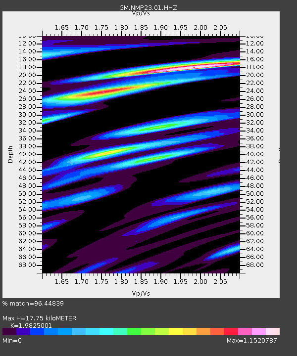
| Estimated Moho Depth: |
17.75 km |
| Estimated Crust Vp/Vs: |
1.98 |
| Assumed Crust Vp: |
6.129 km/s |
| Estimated Crust Vs: |
3.091 km/s |
| Estimated Crust Poisson's Ratio: |
0.33 |
|
| Radial Match: |
96.44839 % |
| Radial Bump: |
357 |
| Transverse Match: |
86.18193 % |
| Transverse Bump: |
400 |
| SOD ConfigId: |
26497111 |
| Insert Time: |
2021-10-25 09:19:57.465 +0000 |
| GWidth: |
2.5 |
| Max Bumps: |
400 |
| Tol: |
0.001 |
|

Signal To Noise
| Channel | StoN | STA | LTA |
| GM:NMP23:01:HHZ:20211011T09:17:50.295007Z | 16.79637 | 4.8648553E-6 | 2.896373E-7 |
| GM:NMP23:01:HHN:20211011T09:17:50.295007Z | 9.189888 | 1.8167268E-6 | 1.9768758E-7 |
| GM:NMP23:01:HHE:20211011T09:17:50.295007Z | 6.414546 | 1.128554E-6 | 1.7593669E-7 |
| Arrivals |
| Ps | 3.0 SECOND |
| PpPs | 8.2 SECOND |
| PsPs/PpSs | 11 SECOND |


