You are here: Home > Network List > GS - US Geological Survey Networks Stations List
> Station ALQ1 ASL Reference STS-2HG > Earthquake Result Viewer
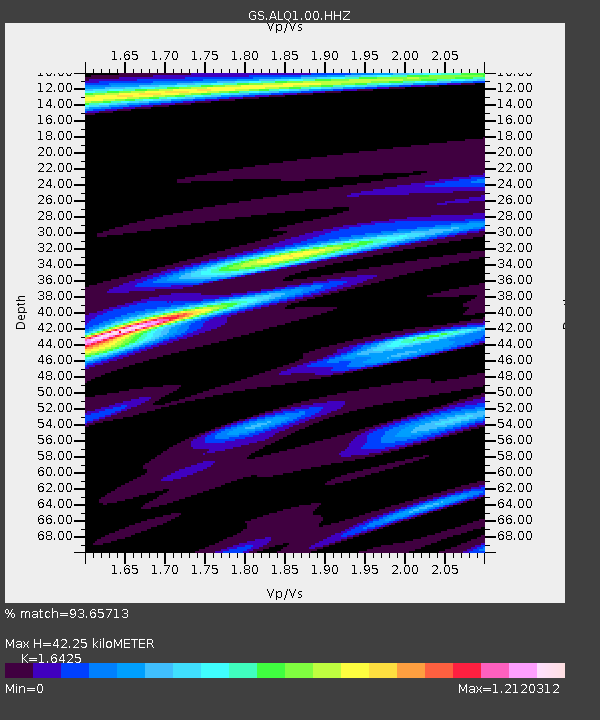
ALQ1 ASL Reference STS-2HG - Earthquake Result Viewer
| Earthquake location: |
Alaska Peninsula |
| Earthquake latitude/longitude: |
56.3/-156.6 |
| Earthquake time(UTC): |
2021/10/11 (284) 09:10:24 GMT |
| Earthquake Depth: |
69 km |
| Earthquake Magnitude: |
6.9 mww |
| Earthquake Catalog/Contributor: |
NEIC PDE/ak |
|
| Network: |
GS US Geological Survey Networks |
| Station: |
ALQ1 ASL Reference STS-2HG |
| Lat/Lon: |
34.94 N/106.46 W |
| Elevation: |
1854 m |
|
| Distance: |
39.9 deg |
| Az: |
100.707 deg |
| Baz: |
318.131 deg |
| Ray Param: |
0.07451087 |
| Estimated Moho Depth: |
42.25 km |
| Estimated Crust Vp/Vs: |
1.64 |
| Assumed Crust Vp: |
6.502 km/s |
| Estimated Crust Vs: |
3.958 km/s |
| Estimated Crust Poisson's Ratio: |
0.21 |
|
| Radial Match: |
93.65713 % |
| Radial Bump: |
284 |
| Transverse Match: |
84.809494 % |
| Transverse Bump: |
400 |
| SOD ConfigId: |
26497111 |
| Insert Time: |
2021-10-25 09:20:03.433 +0000 |
| GWidth: |
2.5 |
| Max Bumps: |
400 |
| Tol: |
0.001 |
|

Signal To Noise
| Channel | StoN | STA | LTA |
| GS:ALQ1:00:HHZ:20211011T09:17:21.408013Z | 23.175522 | 2.7653798E-6 | 1.193233E-7 |
| GS:ALQ1:00:HH1:20211011T09:17:21.408013Z | 11.156085 | 1.2244388E-6 | 1.0975524E-7 |
| GS:ALQ1:00:HH2:20211011T09:17:21.408013Z | 15.386879 | 1.2117589E-6 | 7.875274E-8 |
| Arrivals |
| Ps | 4.5 SECOND |
| PpPs | 16 SECOND |
| PsPs/PpSs | 20 SECOND |


