You are here: Home > Network List > GS - US Geological Survey Networks Stations List
> Station ASL8 Albuquerque, New Mexico, USA > Earthquake Result Viewer
ASL8 Albuquerque, New Mexico, USA - Earthquake Result Viewer

| Earthquake location: |
Alaska Peninsula |
| Earthquake latitude/longitude: |
56.3/-156.6 |
| Earthquake time(UTC): |
2021/10/11 (284) 09:10:24 GMT |
| Earthquake Depth: |
69 km |
| Earthquake Magnitude: |
6.9 mww |
| Earthquake Catalog/Contributor: |
NEIC PDE/ak |
|
| Network: |
GS US Geological Survey Networks |
| Station: |
ASL8 Albuquerque, New Mexico, USA |
| Lat/Lon: |
34.95 N/106.46 W |
| Elevation: |
1820 m |
|
| Distance: |
39.9 deg |
| Az: |
100.703 deg |
| Baz: |
318.128 deg |
| Ray Param: |
0.07451207 |
| Estimated Moho Depth: |
41.5 km |
| Estimated Crust Vp/Vs: |
1.66 |
| Assumed Crust Vp: |
6.502 km/s |
| Estimated Crust Vs: |
3.905 km/s |
| Estimated Crust Poisson's Ratio: |
0.22 |
|
| Radial Match: |
94.092064 % |
| Radial Bump: |
273 |
| Transverse Match: |
85.21469 % |
| Transverse Bump: |
400 |
| SOD ConfigId: |
26497111 |
| Insert Time: |
2021-10-25 09:20:14.538 +0000 |
| GWidth: |
2.5 |
| Max Bumps: |
400 |
| Tol: |
0.001 |
|
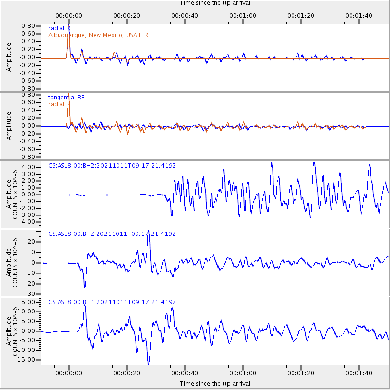
Signal To Noise
| Channel | StoN | STA | LTA |
| GS:ASL8:00:BHZ:20211011T09:17:21.419Z | 27.819345 | 2.8078466E-6 | 1.0093144E-7 |
| GS:ASL8:00:BH1:20211011T09:17:21.419Z | 14.683903 | 1.7114845E-6 | 1.1655516E-7 |
| GS:ASL8:00:BH2:20211011T09:17:21.419Z | 6.928568 | 3.4830418E-7 | 5.0270735E-8 |
| Arrivals |
| Ps | 4.6 SECOND |
| PpPs | 16 SECOND |
| PsPs/PpSs | 20 SECOND |


