You are here: Home > Network List > GS - US Geological Survey Networks Stations List
> Station DEC06 Boomer > Earthquake Result Viewer
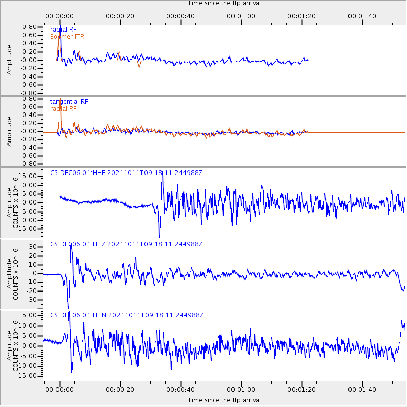
DEC06 Boomer - Earthquake Result Viewer
*The percent match for this event was below the threshold and hence no stack was calculated.
| Earthquake location: |
Alaska Peninsula |
| Earthquake latitude/longitude: |
56.3/-156.6 |
| Earthquake time(UTC): |
2021/10/11 (284) 09:10:24 GMT |
| Earthquake Depth: |
69 km |
| Earthquake Magnitude: |
6.9 mww |
| Earthquake Catalog/Contributor: |
NEIC PDE/ak |
|
| Network: |
GS US Geological Survey Networks |
| Station: |
DEC06 Boomer |
| Lat/Lon: |
39.90 N/88.95 W |
| Elevation: |
215 m |
|
| Distance: |
46.1 deg |
| Az: |
80.949 deg |
| Baz: |
314.248 deg |
| Ray Param: |
$rayparam |
*The percent match for this event was below the threshold and hence was not used in the summary stack. |
|
| Radial Match: |
67.84715 % |
| Radial Bump: |
400 |
| Transverse Match: |
54.40867 % |
| Transverse Bump: |
400 |
| SOD ConfigId: |
26497111 |
| Insert Time: |
2021-10-25 09:20:20.458 +0000 |
| GWidth: |
2.5 |
| Max Bumps: |
400 |
| Tol: |
0.001 |
|
Signal To Noise
| Channel | StoN | STA | LTA |
| GS:DEC06:01:HHZ:20211011T09:18:11.244988Z | 59.53284 | 1.6585689E-5 | 2.7859733E-7 |
| GS:DEC06:01:HHN:20211011T09:18:11.244988Z | 3.3190334 | 8.653141E-6 | 2.6071268E-6 |
| GS:DEC06:01:HHE:20211011T09:18:11.244988Z | 6.387727 | 7.966778E-6 | 1.2472009E-6 |
| Arrivals |
| Ps | |
| PpPs | |
| PsPs/PpSs | |


