You are here: Home > Network List > GS - US Geological Survey Networks Stations List
> Station PR01 PR01, Lajas > Earthquake Result Viewer
PR01 PR01, Lajas - Earthquake Result Viewer
| Earthquake location: |
Alaska Peninsula |
| Earthquake latitude/longitude: |
56.3/-156.6 |
| Earthquake time(UTC): |
2021/10/11 (284) 09:10:24 GMT |
| Earthquake Depth: |
69 km |
| Earthquake Magnitude: |
6.9 mww |
| Earthquake Catalog/Contributor: |
NEIC PDE/ak |
|
| Network: |
GS US Geological Survey Networks |
| Station: |
PR01 PR01, Lajas |
| Lat/Lon: |
18.03 N/67.07 W |
| Elevation: |
33 m |
|
| Distance: |
74.9 deg |
| Az: |
80.183 deg |
| Baz: |
324.697 deg |
| Ray Param: |
0.0518678 |
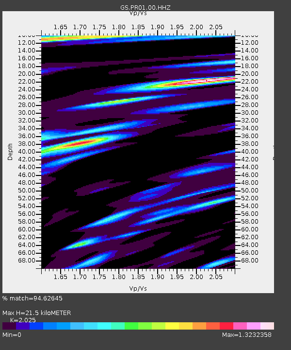
| Estimated Moho Depth: |
21.5 km |
| Estimated Crust Vp/Vs: |
2.03 |
| Assumed Crust Vp: |
5.14 km/s |
| Estimated Crust Vs: |
2.538 km/s |
| Estimated Crust Poisson's Ratio: |
0.34 |
|
| Radial Match: |
94.62645 % |
| Radial Bump: |
400 |
| Transverse Match: |
91.8745 % |
| Transverse Bump: |
400 |
| SOD ConfigId: |
26497111 |
| Insert Time: |
2021-10-25 09:20:33.349 +0000 |
| GWidth: |
2.5 |
| Max Bumps: |
400 |
| Tol: |
0.001 |
|

Signal To Noise
| Channel | StoN | STA | LTA |
| GS:PR01:00:HHZ:20211011T09:21:27.268975Z | 44.630928 | 7.2393277E-6 | 1.6220427E-7 |
| GS:PR01:00:HH1:20211011T09:21:27.268975Z | 7.726234 | 2.6219316E-6 | 3.3935441E-7 |
| GS:PR01:00:HH2:20211011T09:21:27.268975Z | 6.416409 | 1.3829754E-6 | 2.1553727E-7 |
| Arrivals |
| Ps | 4.4 SECOND |
| PpPs | 12 SECOND |
| PsPs/PpSs | 17 SECOND |


