You are here: Home > Network List > HT - Aristotle University of Thessaloniki Seismological Network Stations List
> Station LIT Litochoro, Greece, HT-Net > Earthquake Result Viewer
LIT Litochoro, Greece, HT-Net - Earthquake Result Viewer
| Earthquake location: |
Alaska Peninsula |
| Earthquake latitude/longitude: |
56.3/-156.6 |
| Earthquake time(UTC): |
2021/10/11 (284) 09:10:24 GMT |
| Earthquake Depth: |
69 km |
| Earthquake Magnitude: |
6.9 mww |
| Earthquake Catalog/Contributor: |
NEIC PDE/ak |
|
| Network: |
HT Aristotle University of Thessaloniki Seismological Network |
| Station: |
LIT Litochoro, Greece, HT-Net |
| Lat/Lon: |
40.10 N/22.49 E |
| Elevation: |
480 m |
|
| Distance: |
84.0 deg |
| Az: |
0.738 deg |
| Baz: |
359.463 deg |
| Ray Param: |
0.04565449 |
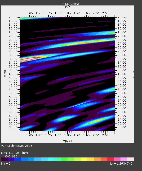
| Estimated Moho Depth: |
32.0 km |
| Estimated Crust Vp/Vs: |
1.63 |
| Assumed Crust Vp: |
6.279 km/s |
| Estimated Crust Vs: |
3.84 km/s |
| Estimated Crust Poisson's Ratio: |
0.20 |
|
| Radial Match: |
88.912636 % |
| Radial Bump: |
400 |
| Transverse Match: |
85.43829 % |
| Transverse Bump: |
400 |
| SOD ConfigId: |
26497111 |
| Insert Time: |
2021-10-25 09:20:55.509 +0000 |
| GWidth: |
2.5 |
| Max Bumps: |
400 |
| Tol: |
0.001 |
|

Signal To Noise
| Channel | StoN | STA | LTA |
| HT:LIT: :HHZ:20211011T09:22:16.390008Z | 67.88079 | 1.0436763E-5 | 1.5375134E-7 |
| HT:LIT: :HHN:20211011T09:22:16.390008Z | 24.418732 | 3.3696326E-6 | 1.3799377E-7 |
| HT:LIT: :HHE:20211011T09:22:16.390008Z | 7.7521553 | 1.3661835E-6 | 1.7623273E-7 |
| Arrivals |
| Ps | 3.3 SECOND |
| PpPs | 13 SECOND |
| PsPs/PpSs | 16 SECOND |


