You are here: Home > Network List > II - Global Seismograph Network (GSN - IRIS/IDA) Stations List
> Station FFC Flin Flon, Canada > Earthquake Result Viewer
FFC Flin Flon, Canada - Earthquake Result Viewer
| Earthquake location: |
Alaska Peninsula |
| Earthquake latitude/longitude: |
56.3/-156.6 |
| Earthquake time(UTC): |
2021/10/11 (284) 09:10:24 GMT |
| Earthquake Depth: |
69 km |
| Earthquake Magnitude: |
6.9 mww |
| Earthquake Catalog/Contributor: |
NEIC PDE/ak |
|
| Network: |
II Global Seismograph Network (GSN - IRIS/IDA) |
| Station: |
FFC Flin Flon, Canada |
| Lat/Lon: |
54.72 N/101.98 W |
| Elevation: |
338 m |
|
| Distance: |
30.3 deg |
| Az: |
69.629 deg |
| Baz: |
295.603 deg |
| Ray Param: |
0.07934933 |
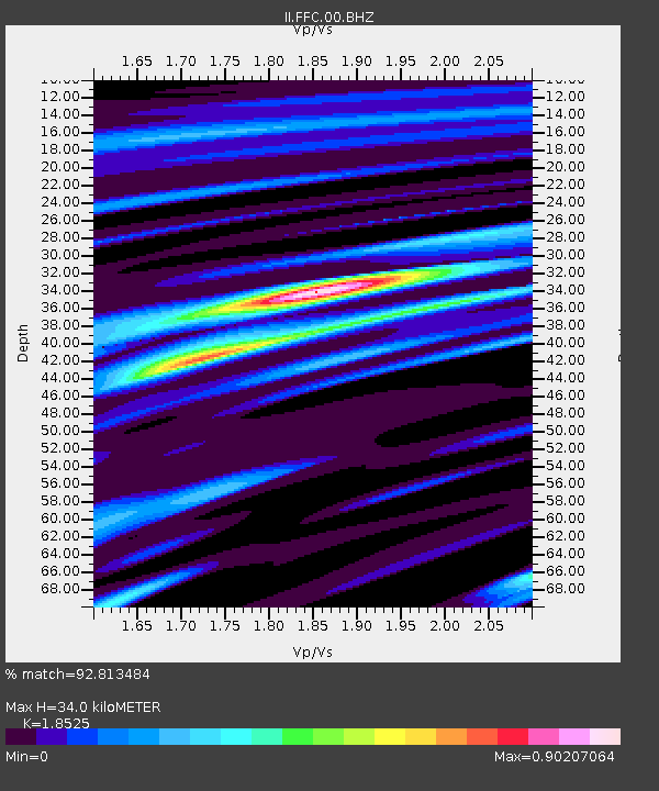
| Estimated Moho Depth: |
34.0 km |
| Estimated Crust Vp/Vs: |
1.85 |
| Assumed Crust Vp: |
6.552 km/s |
| Estimated Crust Vs: |
3.537 km/s |
| Estimated Crust Poisson's Ratio: |
0.29 |
|
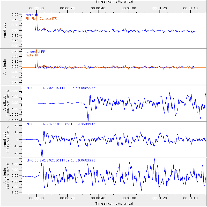
| Radial Match: |
92.813484 % |
| Radial Bump: |
339 |
| Transverse Match: |
68.69303 % |
| Transverse Bump: |
400 |
| SOD ConfigId: |
26497111 |
| Insert Time: |
2021-10-25 09:21:33.230 +0000 |
| GWidth: |
2.5 |
| Max Bumps: |
400 |
| Tol: |
0.001 |
|
Signal To Noise
| Channel | StoN | STA | LTA |
| II:FFC:00:BHZ:20211011T09:15:59.068993Z | 40.349796 | 1.0332616E-5 | 2.5607602E-7 |
| II:FFC:00:BH1:20211011T09:15:59.068993Z | 14.6472845 | 2.6188811E-6 | 1.7879637E-7 |
| II:FFC:00:BH2:20211011T09:15:59.068993Z | 29.26317 | 6.0236416E-6 | 2.0584379E-7 |
| Arrivals |
| Ps | 4.8 SECOND |
| PpPs | 14 SECOND |
| PsPs/PpSs | 18 SECOND |


