You are here: Home > Network List > N4 - Central and EAstern US Network Stations List
> Station E62A Clayton Lake, ME, USA > Earthquake Result Viewer
E62A Clayton Lake, ME, USA - Earthquake Result Viewer
| Earthquake location: |
Alaska Peninsula |
| Earthquake latitude/longitude: |
56.3/-156.6 |
| Earthquake time(UTC): |
2021/10/11 (284) 09:10:24 GMT |
| Earthquake Depth: |
69 km |
| Earthquake Magnitude: |
6.9 mww |
| Earthquake Catalog/Contributor: |
NEIC PDE/ak |
|
| Network: |
N4 Central and EAstern US Network |
| Station: |
E62A Clayton Lake, ME, USA |
| Lat/Lon: |
46.62 N/69.52 W |
| Elevation: |
356 m |
|
| Distance: |
51.6 deg |
| Az: |
61.44 deg |
| Baz: |
314.677 deg |
| Ray Param: |
0.06710979 |
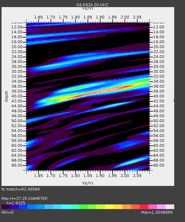
| Estimated Moho Depth: |
37.25 km |
| Estimated Crust Vp/Vs: |
1.93 |
| Assumed Crust Vp: |
6.419 km/s |
| Estimated Crust Vs: |
3.322 km/s |
| Estimated Crust Poisson's Ratio: |
0.32 |
|
| Radial Match: |
92.48599 % |
| Radial Bump: |
400 |
| Transverse Match: |
81.79421 % |
| Transverse Bump: |
400 |
| SOD ConfigId: |
26497111 |
| Insert Time: |
2021-10-25 09:25:12.794 +0000 |
| GWidth: |
2.5 |
| Max Bumps: |
400 |
| Tol: |
0.001 |
|

Signal To Noise
| Channel | StoN | STA | LTA |
| N4:E62A:00:HHZ:20211011T09:18:53.459008Z | 26.766966 | 6.9067014E-6 | 2.580308E-7 |
| N4:E62A:00:HH1:20211011T09:18:53.459008Z | 8.812002 | 1.930815E-6 | 2.1911195E-7 |
| N4:E62A:00:HH2:20211011T09:18:53.459008Z | 8.430489 | 1.9207894E-6 | 2.2783843E-7 |
| Arrivals |
| Ps | 5.7 SECOND |
| PpPs | 16 SECOND |
| PsPs/PpSs | 22 SECOND |


