You are here: Home > Network List > N4 - Central and EAstern US Network Stations List
> Station I40B Norwalk, WI, USA > Earthquake Result Viewer
I40B Norwalk, WI, USA - Earthquake Result Viewer
| Earthquake location: |
Alaska Peninsula |
| Earthquake latitude/longitude: |
56.3/-156.6 |
| Earthquake time(UTC): |
2021/10/11 (284) 09:10:24 GMT |
| Earthquake Depth: |
69 km |
| Earthquake Magnitude: |
6.9 mww |
| Earthquake Catalog/Contributor: |
NEIC PDE/ak |
|
| Network: |
N4 Central and EAstern US Network |
| Station: |
I40B Norwalk, WI, USA |
| Lat/Lon: |
43.89 N/90.62 W |
| Elevation: |
419 m |
|
| Distance: |
42.5 deg |
| Az: |
77.952 deg |
| Baz: |
310.988 deg |
| Ray Param: |
0.07296239 |
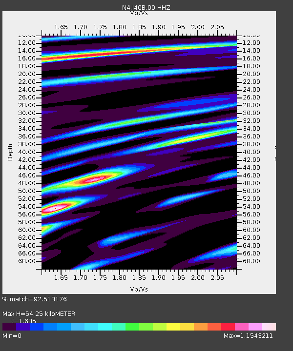
| Estimated Moho Depth: |
54.25 km |
| Estimated Crust Vp/Vs: |
1.63 |
| Assumed Crust Vp: |
6.53 km/s |
| Estimated Crust Vs: |
3.994 km/s |
| Estimated Crust Poisson's Ratio: |
0.20 |
|
| Radial Match: |
92.513176 % |
| Radial Bump: |
339 |
| Transverse Match: |
83.86318 % |
| Transverse Bump: |
400 |
| SOD ConfigId: |
26497111 |
| Insert Time: |
2021-10-25 09:25:21.972 +0000 |
| GWidth: |
2.5 |
| Max Bumps: |
400 |
| Tol: |
0.001 |
|

Signal To Noise
| Channel | StoN | STA | LTA |
| N4:I40B:00:HHZ:20211011T09:17:42.378014Z | 88.21351 | 1.7883589E-5 | 2.0273072E-7 |
| N4:I40B:00:HH1:20211011T09:17:42.378014Z | 32.81924 | 4.652355E-6 | 1.4175694E-7 |
| N4:I40B:00:HH2:20211011T09:17:42.378014Z | 46.641197 | 7.857512E-6 | 1.6846721E-7 |
| Arrivals |
| Ps | 5.7 SECOND |
| PpPs | 20 SECOND |
| PsPs/PpSs | 26 SECOND |


