You are here: Home > Network List > N4 - Central and EAstern US Network Stations List
> Station J57A Williamstown, NY, USA > Earthquake Result Viewer
J57A Williamstown, NY, USA - Earthquake Result Viewer
| Earthquake location: |
Alaska Peninsula |
| Earthquake latitude/longitude: |
56.3/-156.6 |
| Earthquake time(UTC): |
2021/10/11 (284) 09:10:24 GMT |
| Earthquake Depth: |
69 km |
| Earthquake Magnitude: |
6.9 mww |
| Earthquake Catalog/Contributor: |
NEIC PDE/ak |
|
| Network: |
N4 Central and EAstern US Network |
| Station: |
J57A Williamstown, NY, USA |
| Lat/Lon: |
43.41 N/76.00 W |
| Elevation: |
191 m |
|
| Distance: |
50.6 deg |
| Az: |
68.519 deg |
| Baz: |
314.558 deg |
| Ray Param: |
0.06775715 |
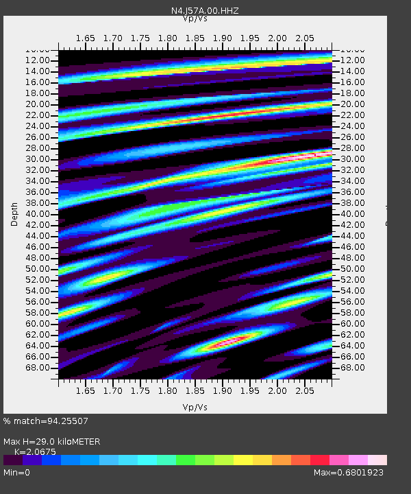
| Estimated Moho Depth: |
29.0 km |
| Estimated Crust Vp/Vs: |
2.07 |
| Assumed Crust Vp: |
6.419 km/s |
| Estimated Crust Vs: |
3.105 km/s |
| Estimated Crust Poisson's Ratio: |
0.35 |
|
| Radial Match: |
94.25507 % |
| Radial Bump: |
323 |
| Transverse Match: |
76.39696 % |
| Transverse Bump: |
400 |
| SOD ConfigId: |
26497111 |
| Insert Time: |
2021-10-25 09:25:31.038 +0000 |
| GWidth: |
2.5 |
| Max Bumps: |
400 |
| Tol: |
0.001 |
|

Signal To Noise
| Channel | StoN | STA | LTA |
| N4:J57A:00:HHZ:20211011T09:18:45.83999Z | 41.07292 | 1.1706621E-5 | 2.8502043E-7 |
| N4:J57A:00:HH1:20211011T09:18:45.83999Z | 25.052181 | 4.7724916E-6 | 1.9050205E-7 |
| N4:J57A:00:HH2:20211011T09:18:45.83999Z | 16.720726 | 4.9046366E-6 | 2.933268E-7 |
| Arrivals |
| Ps | 5.1 SECOND |
| PpPs | 13 SECOND |
| PsPs/PpSs | 18 SECOND |


