You are here: Home > Network List > N4 - Central and EAstern US Network Stations List
> Station L61B Northampton, MA, USA > Earthquake Result Viewer
L61B Northampton, MA, USA - Earthquake Result Viewer
| Earthquake location: |
Alaska Peninsula |
| Earthquake latitude/longitude: |
56.3/-156.6 |
| Earthquake time(UTC): |
2021/10/11 (284) 09:10:24 GMT |
| Earthquake Depth: |
69 km |
| Earthquake Magnitude: |
6.9 mww |
| Earthquake Catalog/Contributor: |
NEIC PDE/ak |
|
| Network: |
N4 Central and EAstern US Network |
| Station: |
L61B Northampton, MA, USA |
| Lat/Lon: |
42.45 N/72.68 W |
| Elevation: |
261 m |
|
| Distance: |
53.0 deg |
| Az: |
67.176 deg |
| Baz: |
315.978 deg |
| Ray Param: |
0.06622119 |
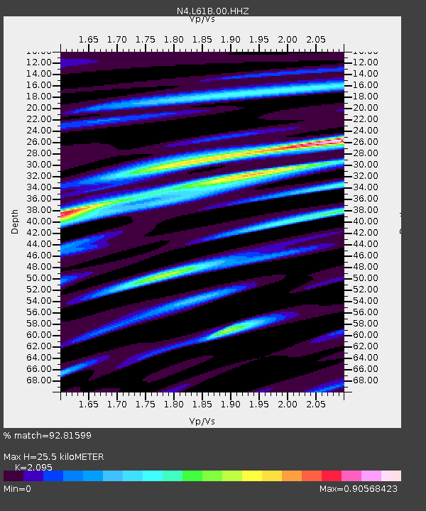
| Estimated Moho Depth: |
25.5 km |
| Estimated Crust Vp/Vs: |
2.10 |
| Assumed Crust Vp: |
6.419 km/s |
| Estimated Crust Vs: |
3.064 km/s |
| Estimated Crust Poisson's Ratio: |
0.35 |
|
| Radial Match: |
92.81599 % |
| Radial Bump: |
400 |
| Transverse Match: |
80.15206 % |
| Transverse Bump: |
400 |
| SOD ConfigId: |
26497111 |
| Insert Time: |
2021-10-25 09:25:51.397 +0000 |
| GWidth: |
2.5 |
| Max Bumps: |
400 |
| Tol: |
0.001 |
|

Signal To Noise
| Channel | StoN | STA | LTA |
| N4:L61B:00:HHZ:20211011T09:19:03.63897Z | 15.766763 | 7.00828E-6 | 4.444971E-7 |
| N4:L61B:00:HH1:20211011T09:19:03.63897Z | 9.775599 | 2.9915782E-6 | 3.0602507E-7 |
| N4:L61B:00:HH2:20211011T09:19:03.63897Z | 6.992997 | 2.1660396E-6 | 3.097441E-7 |
| Arrivals |
| Ps | 4.6 SECOND |
| PpPs | 12 SECOND |
| PsPs/PpSs | 16 SECOND |


