You are here: Home > Network List > NM - Cooperative New Madrid Seismic Network Stations List
> Station HICK Hickman,KY > Earthquake Result Viewer
HICK Hickman,KY - Earthquake Result Viewer
| Earthquake location: |
Alaska Peninsula |
| Earthquake latitude/longitude: |
56.3/-156.6 |
| Earthquake time(UTC): |
2021/10/11 (284) 09:10:24 GMT |
| Earthquake Depth: |
69 km |
| Earthquake Magnitude: |
6.9 mww |
| Earthquake Catalog/Contributor: |
NEIC PDE/ak |
|
| Network: |
NM Cooperative New Madrid Seismic Network |
| Station: |
HICK Hickman,KY |
| Lat/Lon: |
36.54 N/89.23 W |
| Elevation: |
141 m |
|
| Distance: |
48.3 deg |
| Az: |
84.376 deg |
| Baz: |
316.403 deg |
| Ray Param: |
0.069246426 |
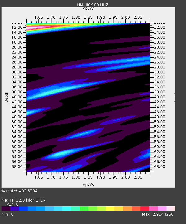
| Estimated Moho Depth: |
12.0 km |
| Estimated Crust Vp/Vs: |
1.60 |
| Assumed Crust Vp: |
6.444 km/s |
| Estimated Crust Vs: |
4.027 km/s |
| Estimated Crust Poisson's Ratio: |
0.18 |
|
| Radial Match: |
83.5734 % |
| Radial Bump: |
400 |
| Transverse Match: |
57.494324 % |
| Transverse Bump: |
400 |
| SOD ConfigId: |
26497111 |
| Insert Time: |
2021-10-25 09:27:55.722 +0000 |
| GWidth: |
2.5 |
| Max Bumps: |
400 |
| Tol: |
0.001 |
|

Signal To Noise
| Channel | StoN | STA | LTA |
| NM:HICK:00:HHZ:20211011T09:18:28.529992Z | 71.02892 | 1.7015822E-5 | 2.3956187E-7 |
| NM:HICK:00:HHN:20211011T09:18:28.529992Z | 6.1454434 | 6.3936095E-6 | 1.0403821E-6 |
| NM:HICK:00:HHE:20211011T09:18:28.529992Z | 6.1954904 | 3.929341E-6 | 6.3422596E-7 |
| Arrivals |
| Ps | 1.2 SECOND |
| PpPs | 4.5 SECOND |
| PsPs/PpSs | 5.7 SECOND |


