You are here: Home > Network List > NM - Cooperative New Madrid Seismic Network Stations List
> Station PVMO UM Delta Research Portageville, MO > Earthquake Result Viewer
PVMO UM Delta Research Portageville, MO - Earthquake Result Viewer
| Earthquake location: |
Alaska Peninsula |
| Earthquake latitude/longitude: |
56.3/-156.6 |
| Earthquake time(UTC): |
2021/10/11 (284) 09:10:24 GMT |
| Earthquake Depth: |
69 km |
| Earthquake Magnitude: |
6.9 mww |
| Earthquake Catalog/Contributor: |
NEIC PDE/ak |
|
| Network: |
NM Cooperative New Madrid Seismic Network |
| Station: |
PVMO UM Delta Research Portageville, MO |
| Lat/Lon: |
36.41 N/89.70 W |
| Elevation: |
98 m |
|
| Distance: |
48.1 deg |
| Az: |
84.862 deg |
| Baz: |
316.449 deg |
| Ray Param: |
0.06935599 |
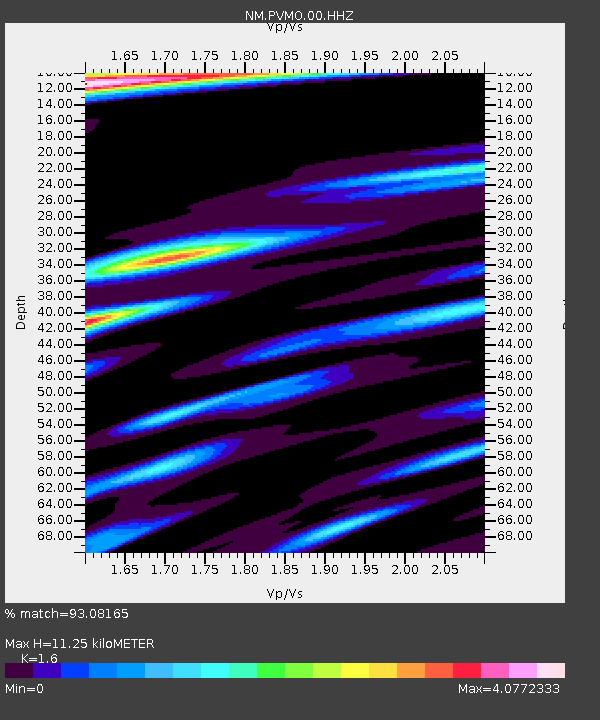
| Estimated Moho Depth: |
11.25 km |
| Estimated Crust Vp/Vs: |
1.60 |
| Assumed Crust Vp: |
6.444 km/s |
| Estimated Crust Vs: |
4.027 km/s |
| Estimated Crust Poisson's Ratio: |
0.18 |
|
| Radial Match: |
93.08165 % |
| Radial Bump: |
367 |
| Transverse Match: |
82.00728 % |
| Transverse Bump: |
400 |
| SOD ConfigId: |
26497111 |
| Insert Time: |
2021-10-25 09:28:09.790 +0000 |
| GWidth: |
2.5 |
| Max Bumps: |
400 |
| Tol: |
0.001 |
|

Signal To Noise
| Channel | StoN | STA | LTA |
| NM:PVMO:00:HHZ:20211011T09:18:27.219994Z | 56.949043 | 1.8490045E-5 | 3.24677E-7 |
| NM:PVMO:00:HHN:20211011T09:18:27.219994Z | 10.033029 | 6.7913816E-6 | 6.7690246E-7 |
| NM:PVMO:00:HHE:20211011T09:18:27.219994Z | 19.227875 | 1.1567828E-5 | 6.016176E-7 |
| Arrivals |
| Ps | 1.1 SECOND |
| PpPs | 4.2 SECOND |
| PsPs/PpSs | 5.4 SECOND |


