You are here: Home > Network List > NN - Western Great Basin/Eastern Sierra Nevada Stations List
> Station MCA06 Monte Cristo ASL 06 > Earthquake Result Viewer
MCA06 Monte Cristo ASL 06 - Earthquake Result Viewer
| Earthquake location: |
Alaska Peninsula |
| Earthquake latitude/longitude: |
56.3/-156.6 |
| Earthquake time(UTC): |
2021/10/11 (284) 09:10:24 GMT |
| Earthquake Depth: |
69 km |
| Earthquake Magnitude: |
6.9 mww |
| Earthquake Catalog/Contributor: |
NEIC PDE/ak |
|
| Network: |
NN Western Great Basin/Eastern Sierra Nevada |
| Station: |
MCA06 Monte Cristo ASL 06 |
| Lat/Lon: |
38.01 N/117.88 W |
| Elevation: |
1462 m |
|
| Distance: |
31.5 deg |
| Az: |
108.961 deg |
| Baz: |
318.079 deg |
| Ray Param: |
0.07891744 |
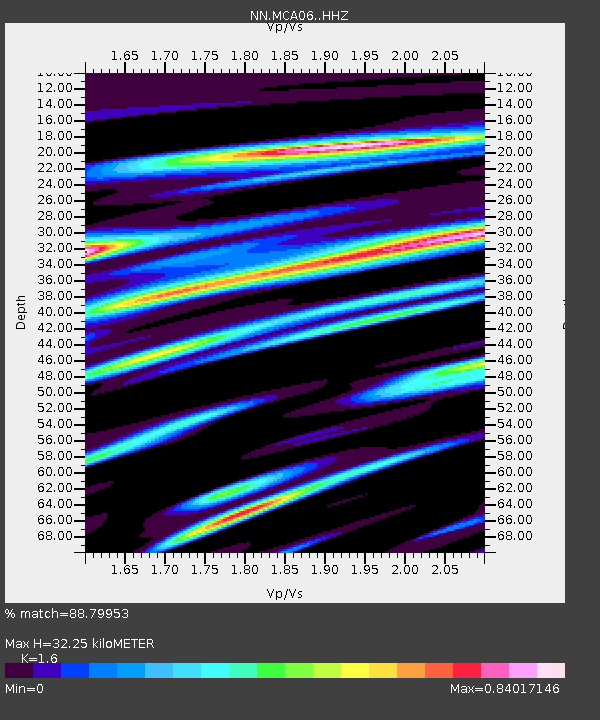
| Estimated Moho Depth: |
32.25 km |
| Estimated Crust Vp/Vs: |
1.60 |
| Assumed Crust Vp: |
6.276 km/s |
| Estimated Crust Vs: |
3.922 km/s |
| Estimated Crust Poisson's Ratio: |
0.18 |
|
| Radial Match: |
88.79953 % |
| Radial Bump: |
400 |
| Transverse Match: |
68.86185 % |
| Transverse Bump: |
400 |
| SOD ConfigId: |
26497111 |
| Insert Time: |
2021-10-25 09:28:31.473 +0000 |
| GWidth: |
2.5 |
| Max Bumps: |
400 |
| Tol: |
0.001 |
|

Signal To Noise
| Channel | StoN | STA | LTA |
| NN:MCA06: :HHZ:20211011T09:16:09.429986Z | 23.281399 | 2.969506E-6 | 1.2754843E-7 |
| NN:MCA06: :HHN:20211011T09:16:09.429986Z | 7.2874136 | 1.1780718E-6 | 1.6165842E-7 |
| NN:MCA06: :HHE:20211011T09:16:09.429986Z | 6.328943 | 8.510104E-7 | 1.3446328E-7 |
| Arrivals |
| Ps | 3.4 SECOND |
| PpPs | 12 SECOND |
| PsPs/PpSs | 16 SECOND |


