You are here: Home > Network List > O2 - Oklahoma Consolidated Temporary Seismic Networks Stations List
> Station SC20 Lookeba, Oklahoma, USA > Earthquake Result Viewer
SC20 Lookeba, Oklahoma, USA - Earthquake Result Viewer
| Earthquake location: |
Alaska Peninsula |
| Earthquake latitude/longitude: |
56.3/-156.6 |
| Earthquake time(UTC): |
2021/10/11 (284) 09:10:24 GMT |
| Earthquake Depth: |
69 km |
| Earthquake Magnitude: |
6.9 mww |
| Earthquake Catalog/Contributor: |
NEIC PDE/ak |
|
| Network: |
O2 Oklahoma Consolidated Temporary Seismic Networks |
| Station: |
SC20 Lookeba, Oklahoma, USA |
| Lat/Lon: |
35.40 N/98.44 W |
| Elevation: |
490 m |
|
| Distance: |
44.0 deg |
| Az: |
92.994 deg |
| Baz: |
316.988 deg |
| Ray Param: |
0.07199988 |
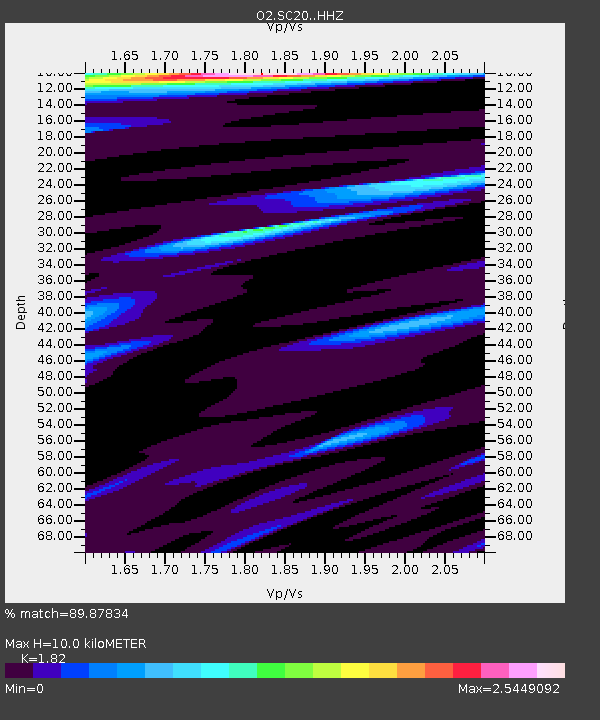
| Estimated Moho Depth: |
10.0 km |
| Estimated Crust Vp/Vs: |
1.82 |
| Assumed Crust Vp: |
6.315 km/s |
| Estimated Crust Vs: |
3.47 km/s |
| Estimated Crust Poisson's Ratio: |
0.28 |
|
| Radial Match: |
89.87834 % |
| Radial Bump: |
285 |
| Transverse Match: |
79.17723 % |
| Transverse Bump: |
357 |
| SOD ConfigId: |
26497111 |
| Insert Time: |
2021-10-25 09:30:28.131 +0000 |
| GWidth: |
2.5 |
| Max Bumps: |
400 |
| Tol: |
0.001 |
|

Signal To Noise
| Channel | StoN | STA | LTA |
| O2:SC20: :HHZ:20211011T09:17:54.765008Z | 36.068954 | 1.0811834E-5 | 2.9975453E-7 |
| O2:SC20: :HHN:20211011T09:17:54.765008Z | 14.187227 | 3.5824253E-6 | 2.525106E-7 |
| O2:SC20: :HHE:20211011T09:17:54.765008Z | 7.728851 | 2.3182674E-6 | 2.9994982E-7 |
| Arrivals |
| Ps | 1.4 SECOND |
| PpPs | 4.2 SECOND |
| PsPs/PpSs | 5.6 SECOND |


