You are here: Home > Network List > OH - Ohio Seismic Network Stations List
> Station LEBO Lake Erie Bluffs Ohio > Earthquake Result Viewer
LEBO Lake Erie Bluffs Ohio - Earthquake Result Viewer
| Earthquake location: |
Alaska Peninsula |
| Earthquake latitude/longitude: |
56.3/-156.6 |
| Earthquake time(UTC): |
2021/10/11 (284) 09:10:24 GMT |
| Earthquake Depth: |
69 km |
| Earthquake Magnitude: |
6.9 mww |
| Earthquake Catalog/Contributor: |
NEIC PDE/ak |
|
| Network: |
OH Ohio Seismic Network |
| Station: |
LEBO Lake Erie Bluffs Ohio |
| Lat/Lon: |
41.79 N/81.18 W |
| Elevation: |
188 m |
|
| Distance: |
49.0 deg |
| Az: |
73.544 deg |
| Baz: |
314.307 deg |
| Ray Param: |
0.06880033 |
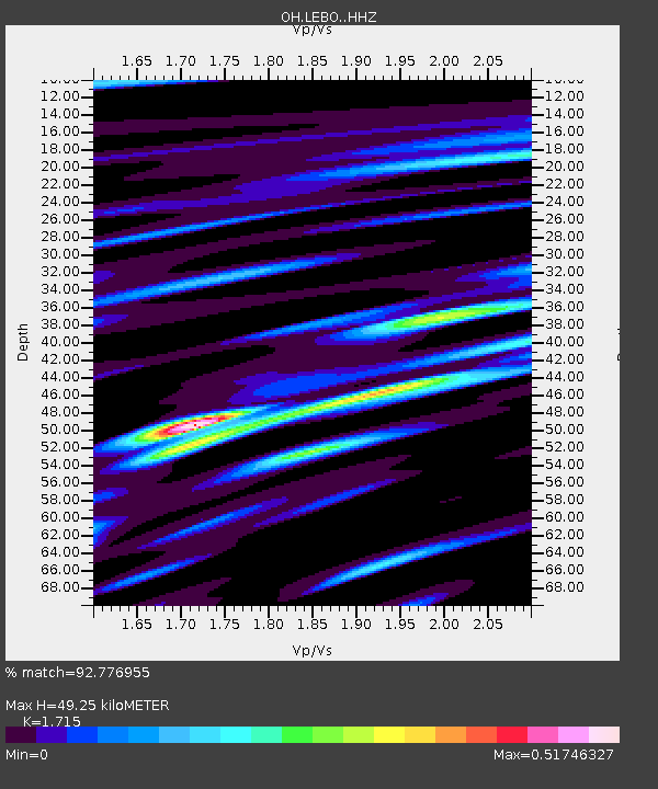
| Estimated Moho Depth: |
49.25 km |
| Estimated Crust Vp/Vs: |
1.72 |
| Assumed Crust Vp: |
6.483 km/s |
| Estimated Crust Vs: |
3.78 km/s |
| Estimated Crust Poisson's Ratio: |
0.24 |
|
| Radial Match: |
92.776955 % |
| Radial Bump: |
230 |
| Transverse Match: |
72.82245 % |
| Transverse Bump: |
400 |
| SOD ConfigId: |
26497111 |
| Insert Time: |
2021-10-25 09:30:48.779 +0000 |
| GWidth: |
2.5 |
| Max Bumps: |
400 |
| Tol: |
0.001 |
|

Signal To Noise
| Channel | StoN | STA | LTA |
| OH:LEBO: :HHZ:20211011T09:18:33.740014Z | 26.325584 | 1.131902E-5 | 4.2996274E-7 |
| OH:LEBO: :HHN:20211011T09:18:33.740014Z | 12.351984 | 3.781157E-6 | 3.0611736E-7 |
| OH:LEBO: :HHE:20211011T09:18:33.740014Z | 14.509299 | 4.844615E-6 | 3.3389725E-7 |
| Arrivals |
| Ps | 5.8 SECOND |
| PpPs | 19 SECOND |
| PsPs/PpSs | 25 SECOND |


