You are here: Home > Network List > OK - Oklahoma Seismic Network Stations List
> Station CSTR Hydro, Oklahoma, USA > Earthquake Result Viewer
CSTR Hydro, Oklahoma, USA - Earthquake Result Viewer
| Earthquake location: |
Alaska Peninsula |
| Earthquake latitude/longitude: |
56.3/-156.6 |
| Earthquake time(UTC): |
2021/10/11 (284) 09:10:24 GMT |
| Earthquake Depth: |
69 km |
| Earthquake Magnitude: |
6.9 mww |
| Earthquake Catalog/Contributor: |
NEIC PDE/ak |
|
| Network: |
OK Oklahoma Seismic Network |
| Station: |
CSTR Hydro, Oklahoma, USA |
| Lat/Lon: |
35.65 N/98.69 W |
| Elevation: |
516 m |
|
| Distance: |
43.7 deg |
| Az: |
92.968 deg |
| Baz: |
316.826 deg |
| Ray Param: |
0.07218161 |
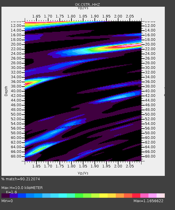
| Estimated Moho Depth: |
10.0 km |
| Estimated Crust Vp/Vs: |
1.60 |
| Assumed Crust Vp: |
6.315 km/s |
| Estimated Crust Vs: |
3.947 km/s |
| Estimated Crust Poisson's Ratio: |
0.18 |
|
| Radial Match: |
90.212074 % |
| Radial Bump: |
389 |
| Transverse Match: |
75.4617 % |
| Transverse Bump: |
400 |
| SOD ConfigId: |
26497111 |
| Insert Time: |
2021-10-25 09:31:05.307 +0000 |
| GWidth: |
2.5 |
| Max Bumps: |
400 |
| Tol: |
0.001 |
|

Signal To Noise
| Channel | StoN | STA | LTA |
| OK:CSTR: :HHZ:20211011T09:17:52.244988Z | 22.407558 | 1.2546698E-6 | 5.5993148E-8 |
| OK:CSTR: :HHN:20211011T09:17:52.244988Z | 4.5742745 | 3.9240004E-7 | 8.578411E-8 |
| OK:CSTR: :HHE:20211011T09:17:52.244988Z | 5.580268 | 2.9011608E-7 | 5.198963E-8 |
| Arrivals |
| Ps | 1.0 SECOND |
| PpPs | 3.8 SECOND |
| PsPs/PpSs | 4.9 SECOND |


