You are here: Home > Network List > OK - Oklahoma Seismic Network Stations List
> Station NOKA Waynoka, Oklahoma, USA > Earthquake Result Viewer
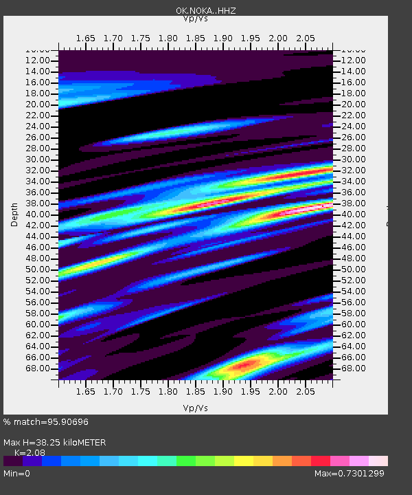
NOKA Waynoka, Oklahoma, USA - Earthquake Result Viewer
| Earthquake location: |
Alaska Peninsula |
| Earthquake latitude/longitude: |
56.3/-156.6 |
| Earthquake time(UTC): |
2021/10/11 (284) 09:10:24 GMT |
| Earthquake Depth: |
69 km |
| Earthquake Magnitude: |
6.9 mww |
| Earthquake Catalog/Contributor: |
NEIC PDE/ak |
|
| Network: |
OK Oklahoma Seismic Network |
| Station: |
NOKA Waynoka, Oklahoma, USA |
| Lat/Lon: |
36.63 N/98.93 W |
| Elevation: |
476 m |
|
| Distance: |
42.8 deg |
| Az: |
92.184 deg |
| Baz: |
316.113 deg |
| Ray Param: |
0.072727285 |
| Estimated Moho Depth: |
38.25 km |
| Estimated Crust Vp/Vs: |
2.08 |
| Assumed Crust Vp: |
6.426 km/s |
| Estimated Crust Vs: |
3.089 km/s |
| Estimated Crust Poisson's Ratio: |
0.35 |
|
| Radial Match: |
95.90696 % |
| Radial Bump: |
333 |
| Transverse Match: |
87.94618 % |
| Transverse Bump: |
356 |
| SOD ConfigId: |
26497111 |
| Insert Time: |
2021-10-25 09:31:15.080 +0000 |
| GWidth: |
2.5 |
| Max Bumps: |
400 |
| Tol: |
0.001 |
|

Signal To Noise
| Channel | StoN | STA | LTA |
| OK:NOKA: :HHZ:20211011T09:17:45.395013Z | 31.712152 | 1.34884385E-5 | 4.2533972E-7 |
| OK:NOKA: :HHN:20211011T09:17:45.395013Z | 6.261059 | 3.9320903E-6 | 6.2802326E-7 |
| OK:NOKA: :HHE:20211011T09:17:45.395013Z | 10.0640955 | 4.1692097E-6 | 4.142657E-7 |
| Arrivals |
| Ps | 6.8 SECOND |
| PpPs | 17 SECOND |
| PsPs/PpSs | 24 SECOND |


