You are here: Home > Network List > OK - Oklahoma Seismic Network Stations List
> Station W35A Tecumseh, Oklahoma, USA > Earthquake Result Viewer
W35A Tecumseh, Oklahoma, USA - Earthquake Result Viewer
| Earthquake location: |
Alaska Peninsula |
| Earthquake latitude/longitude: |
56.3/-156.6 |
| Earthquake time(UTC): |
2021/10/11 (284) 09:10:24 GMT |
| Earthquake Depth: |
69 km |
| Earthquake Magnitude: |
6.9 mww |
| Earthquake Catalog/Contributor: |
NEIC PDE/ak |
|
| Network: |
OK Oklahoma Seismic Network |
| Station: |
W35A Tecumseh, Oklahoma, USA |
| Lat/Lon: |
35.15 N/96.87 W |
| Elevation: |
322 m |
|
| Distance: |
45.1 deg |
| Az: |
91.898 deg |
| Baz: |
317.108 deg |
| Ray Param: |
0.07132227 |
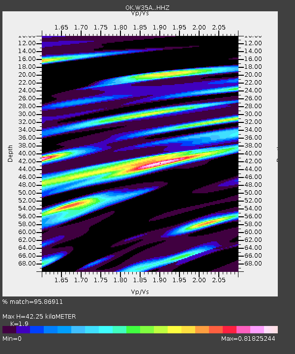
| Estimated Moho Depth: |
42.25 km |
| Estimated Crust Vp/Vs: |
1.90 |
| Assumed Crust Vp: |
6.426 km/s |
| Estimated Crust Vs: |
3.382 km/s |
| Estimated Crust Poisson's Ratio: |
0.31 |
|
| Radial Match: |
95.86911 % |
| Radial Bump: |
334 |
| Transverse Match: |
87.3106 % |
| Transverse Bump: |
395 |
| SOD ConfigId: |
26497111 |
| Insert Time: |
2021-10-25 09:31:21.801 +0000 |
| GWidth: |
2.5 |
| Max Bumps: |
400 |
| Tol: |
0.001 |
|

Signal To Noise
| Channel | StoN | STA | LTA |
| OK:W35A: :HHZ:20211011T09:18:03.165002Z | 64.62023 | 1.2786455E-5 | 1.9787079E-7 |
| OK:W35A: :HHN:20211011T09:18:03.165002Z | 21.365156 | 5.1417805E-6 | 2.4066196E-7 |
| OK:W35A: :HHE:20211011T09:18:03.165002Z | 24.165947 | 4.3011473E-6 | 1.7798381E-7 |
| Arrivals |
| Ps | 6.3 SECOND |
| PpPs | 18 SECOND |
| PsPs/PpSs | 24 SECOND |


