You are here: Home > Network List > TX - Texas Seismological Network Stations List
> Station ET01 Chireno > Earthquake Result Viewer
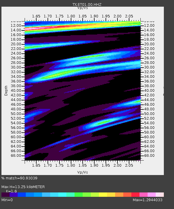
ET01 Chireno - Earthquake Result Viewer
| Earthquake location: |
Alaska Peninsula |
| Earthquake latitude/longitude: |
56.3/-156.6 |
| Earthquake time(UTC): |
2021/10/11 (284) 09:10:24 GMT |
| Earthquake Depth: |
69 km |
| Earthquake Magnitude: |
6.9 mww |
| Earthquake Catalog/Contributor: |
NEIC PDE/ak |
|
| Network: |
TX Texas Seismological Network |
| Station: |
ET01 Chireno |
| Lat/Lon: |
31.46 N/94.37 W |
| Elevation: |
127 m |
|
| Distance: |
49.2 deg |
| Az: |
93.104 deg |
| Baz: |
319.302 deg |
| Ray Param: |
0.06867391 |
| Estimated Moho Depth: |
13.25 km |
| Estimated Crust Vp/Vs: |
1.60 |
| Assumed Crust Vp: |
5.738 km/s |
| Estimated Crust Vs: |
3.587 km/s |
| Estimated Crust Poisson's Ratio: |
0.18 |
|
| Radial Match: |
90.93039 % |
| Radial Bump: |
400 |
| Transverse Match: |
83.87596 % |
| Transverse Bump: |
400 |
| SOD ConfigId: |
26497111 |
| Insert Time: |
2021-10-25 09:34:41.280 +0000 |
| GWidth: |
2.5 |
| Max Bumps: |
400 |
| Tol: |
0.001 |
|

Signal To Noise
| Channel | StoN | STA | LTA |
| TX:ET01:00:HHZ:20211011T09:18:35.33001Z | 34.439465 | 8.499134E-6 | 2.4678474E-7 |
| TX:ET01:00:HH1:20211011T09:18:35.33001Z | 6.0227847 | 2.6416742E-6 | 4.386134E-7 |
| TX:ET01:00:HH2:20211011T09:18:35.33001Z | 0.796758 | 5.226994E-7 | 6.5603285E-7 |
| Arrivals |
| Ps | 1.5 SECOND |
| PpPs | 5.7 SECOND |
| PsPs/PpSs | 7.2 SECOND |


