You are here: Home > Network List > TX - Texas Seismological Network Stations List
> Station FW05 UT at Dallas > Earthquake Result Viewer
FW05 UT at Dallas - Earthquake Result Viewer
| Earthquake location: |
Alaska Peninsula |
| Earthquake latitude/longitude: |
56.3/-156.6 |
| Earthquake time(UTC): |
2021/10/11 (284) 09:10:24 GMT |
| Earthquake Depth: |
69 km |
| Earthquake Magnitude: |
6.9 mww |
| Earthquake Catalog/Contributor: |
NEIC PDE/ak |
|
| Network: |
TX Texas Seismological Network |
| Station: |
FW05 UT at Dallas |
| Lat/Lon: |
32.99 N/96.75 W |
| Elevation: |
207 m |
|
| Distance: |
46.7 deg |
| Az: |
93.808 deg |
| Baz: |
318.509 deg |
| Ray Param: |
0.07025864 |
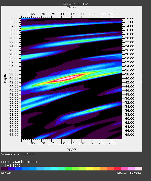
| Estimated Moho Depth: |
39.5 km |
| Estimated Crust Vp/Vs: |
1.83 |
| Assumed Crust Vp: |
6.38 km/s |
| Estimated Crust Vs: |
3.491 km/s |
| Estimated Crust Poisson's Ratio: |
0.29 |
|
| Radial Match: |
93.384865 % |
| Radial Bump: |
342 |
| Transverse Match: |
85.19715 % |
| Transverse Bump: |
400 |
| SOD ConfigId: |
26497111 |
| Insert Time: |
2021-10-25 09:34:47.514 +0000 |
| GWidth: |
2.5 |
| Max Bumps: |
400 |
| Tol: |
0.001 |
|

Signal To Noise
| Channel | StoN | STA | LTA |
| TX:FW05:00:HHZ:20211011T09:18:16.279992Z | 44.942287 | 1.0262716E-5 | 2.2835322E-7 |
| TX:FW05:00:HH1:20211011T09:18:16.279992Z | 13.335205 | 3.3748952E-6 | 2.5308162E-7 |
| TX:FW05:00:HH2:20211011T09:18:16.279992Z | 6.9157367 | 1.7070088E-6 | 2.4682964E-7 |
| Arrivals |
| Ps | 5.4 SECOND |
| PpPs | 17 SECOND |
| PsPs/PpSs | 22 SECOND |


