You are here: Home > Network List > TX - Texas Seismological Network Stations List
> Station FW06 Azle > Earthquake Result Viewer
FW06 Azle - Earthquake Result Viewer
| Earthquake location: |
Alaska Peninsula |
| Earthquake latitude/longitude: |
56.3/-156.6 |
| Earthquake time(UTC): |
2021/10/11 (284) 09:10:24 GMT |
| Earthquake Depth: |
69 km |
| Earthquake Magnitude: |
6.9 mww |
| Earthquake Catalog/Contributor: |
NEIC PDE/ak |
|
| Network: |
TX Texas Seismological Network |
| Station: |
FW06 Azle |
| Lat/Lon: |
32.97 N/97.56 W |
| Elevation: |
233 m |
|
| Distance: |
46.3 deg |
| Az: |
94.526 deg |
| Baz: |
318.564 deg |
| Ray Param: |
0.07054232 |
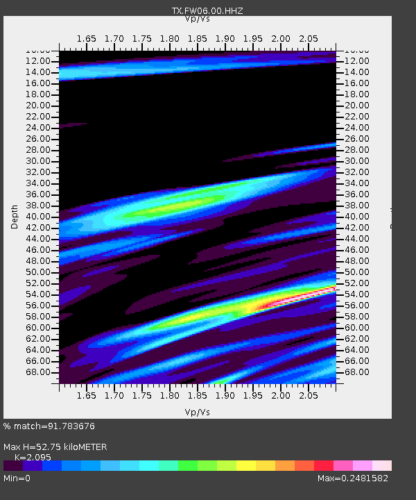
| Estimated Moho Depth: |
52.75 km |
| Estimated Crust Vp/Vs: |
2.10 |
| Assumed Crust Vp: |
6.38 km/s |
| Estimated Crust Vs: |
3.046 km/s |
| Estimated Crust Poisson's Ratio: |
0.35 |
|
| Radial Match: |
91.783676 % |
| Radial Bump: |
400 |
| Transverse Match: |
83.917206 % |
| Transverse Bump: |
400 |
| SOD ConfigId: |
26497111 |
| Insert Time: |
2021-10-25 09:34:47.920 +0000 |
| GWidth: |
2.5 |
| Max Bumps: |
400 |
| Tol: |
0.001 |
|

Signal To Noise
| Channel | StoN | STA | LTA |
| TX:FW06:00:HHZ:20211011T09:18:12.860009Z | 19.983126 | 1.1811393E-5 | 5.9106833E-7 |
| TX:FW06:00:HH1:20211011T09:18:12.860009Z | 9.473485 | 6.9939133E-6 | 7.382619E-7 |
| TX:FW06:00:HH2:20211011T09:18:12.860009Z | 11.597642 | 4.764382E-6 | 4.1080608E-7 |
| Arrivals |
| Ps | 9.5 SECOND |
| PpPs | 24 SECOND |
| PsPs/PpSs | 34 SECOND |


