You are here: Home > Network List > TX - Texas Seismological Network Stations List
> Station FW12 Venus > Earthquake Result Viewer
FW12 Venus - Earthquake Result Viewer

| Earthquake location: |
Alaska Peninsula |
| Earthquake latitude/longitude: |
56.3/-156.6 |
| Earthquake time(UTC): |
2021/10/11 (284) 09:10:24 GMT |
| Earthquake Depth: |
69 km |
| Earthquake Magnitude: |
6.9 mww |
| Earthquake Catalog/Contributor: |
NEIC PDE/ak |
|
| Network: |
TX Texas Seismological Network |
| Station: |
FW12 Venus |
| Lat/Lon: |
32.50 N/97.15 W |
| Elevation: |
204 m |
|
| Distance: |
46.9 deg |
| Az: |
94.599 deg |
| Baz: |
318.834 deg |
| Ray Param: |
0.0701627 |
| Estimated Moho Depth: |
40.25 km |
| Estimated Crust Vp/Vs: |
1.84 |
| Assumed Crust Vp: |
6.38 km/s |
| Estimated Crust Vs: |
3.468 km/s |
| Estimated Crust Poisson's Ratio: |
0.29 |
|
| Radial Match: |
91.147934 % |
| Radial Bump: |
400 |
| Transverse Match: |
88.16172 % |
| Transverse Bump: |
379 |
| SOD ConfigId: |
26497111 |
| Insert Time: |
2021-10-25 09:34:54.072 +0000 |
| GWidth: |
2.5 |
| Max Bumps: |
400 |
| Tol: |
0.001 |
|
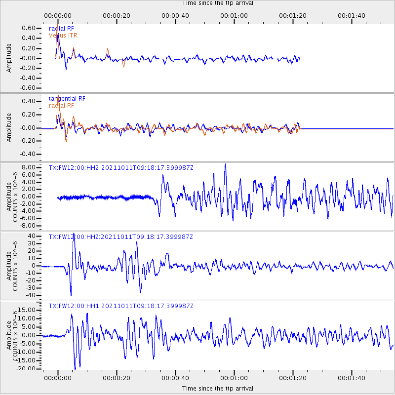
Signal To Noise
| Channel | StoN | STA | LTA |
| TX:FW12:00:HHZ:20211011T09:18:17.399987Z | 61.485317 | 1.1340006E-5 | 1.8443437E-7 |
| TX:FW12:00:HH1:20211011T09:18:17.399987Z | 15.659806 | 3.5742098E-6 | 2.28241E-7 |
| TX:FW12:00:HH2:20211011T09:18:17.399987Z | 6.2592926 | 1.5850608E-6 | 2.5323322E-7 |
| Arrivals |
| Ps | 5.6 SECOND |
| PpPs | 17 SECOND |
| PsPs/PpSs | 23 SECOND |


