You are here: Home > Network List > TX - Texas Seismological Network Stations List
> Station HNDO Hondo > Earthquake Result Viewer
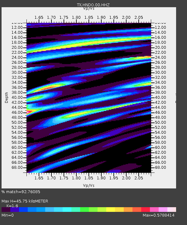
HNDO Hondo - Earthquake Result Viewer
| Earthquake location: |
Alaska Peninsula |
| Earthquake latitude/longitude: |
56.3/-156.6 |
| Earthquake time(UTC): |
2021/10/11 (284) 09:10:24 GMT |
| Earthquake Depth: |
69 km |
| Earthquake Magnitude: |
6.9 mww |
| Earthquake Catalog/Contributor: |
NEIC PDE/ak |
|
| Network: |
TX Texas Seismological Network |
| Station: |
HNDO Hondo |
| Lat/Lon: |
29.53 N/99.28 W |
| Elevation: |
381 m |
|
| Distance: |
47.9 deg |
| Az: |
99.095 deg |
| Baz: |
320.784 deg |
| Ray Param: |
0.069478385 |
| Estimated Moho Depth: |
45.75 km |
| Estimated Crust Vp/Vs: |
1.60 |
| Assumed Crust Vp: |
6.347 km/s |
| Estimated Crust Vs: |
3.967 km/s |
| Estimated Crust Poisson's Ratio: |
0.18 |
|
| Radial Match: |
92.76085 % |
| Radial Bump: |
288 |
| Transverse Match: |
85.055374 % |
| Transverse Bump: |
400 |
| SOD ConfigId: |
26497111 |
| Insert Time: |
2021-10-25 09:35:01.293 +0000 |
| GWidth: |
2.5 |
| Max Bumps: |
400 |
| Tol: |
0.001 |
|

Signal To Noise
| Channel | StoN | STA | LTA |
| TX:HNDO:00:HHZ:20211011T09:18:25.765008Z | 45.159054 | 6.7577594E-6 | 1.496435E-7 |
| TX:HNDO:00:HH1:20211011T09:18:25.765008Z | 14.411069 | 1.1853782E-6 | 8.225471E-8 |
| TX:HNDO:00:HH2:20211011T09:18:25.765008Z | 27.745575 | 3.4218538E-6 | 1.2332971E-7 |
| Arrivals |
| Ps | 4.6 SECOND |
| PpPs | 18 SECOND |
| PsPs/PpSs | 22 SECOND |


