You are here: Home > Network List > TX - Texas Seismological Network Stations List
> Station PB05 Z > Earthquake Result Viewer
PB05 Z - Earthquake Result Viewer
| Earthquake location: |
Alaska Peninsula |
| Earthquake latitude/longitude: |
56.3/-156.6 |
| Earthquake time(UTC): |
2021/10/11 (284) 09:10:24 GMT |
| Earthquake Depth: |
69 km |
| Earthquake Magnitude: |
6.9 mww |
| Earthquake Catalog/Contributor: |
NEIC PDE/ak |
|
| Network: |
TX Texas Seismological Network |
| Station: |
PB05 Z |
| Lat/Lon: |
30.92 N/103.32 W |
| Elevation: |
957 m |
|
| Distance: |
44.7 deg |
| Az: |
101.622 deg |
| Baz: |
320.505 deg |
| Ray Param: |
0.071580514 |
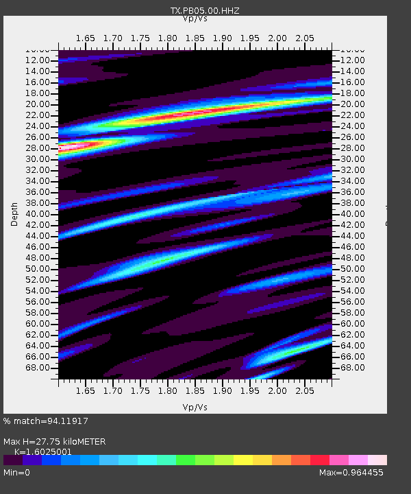
| Estimated Moho Depth: |
27.75 km |
| Estimated Crust Vp/Vs: |
1.60 |
| Assumed Crust Vp: |
6.121 km/s |
| Estimated Crust Vs: |
3.819 km/s |
| Estimated Crust Poisson's Ratio: |
0.18 |
|
| Radial Match: |
94.11917 % |
| Radial Bump: |
342 |
| Transverse Match: |
87.9624 % |
| Transverse Bump: |
400 |
| SOD ConfigId: |
26497111 |
| Insert Time: |
2021-10-25 09:35:21.440 +0000 |
| GWidth: |
2.5 |
| Max Bumps: |
400 |
| Tol: |
0.001 |
|

Signal To Noise
| Channel | StoN | STA | LTA |
| TX:PB05:00:HHZ:20211011T09:18:00.010003Z | 18.74982 | 3.0829822E-6 | 1.6442729E-7 |
| TX:PB05:00:HH1:20211011T09:18:00.010003Z | 13.171705 | 1.3930313E-6 | 1.0575937E-7 |
| TX:PB05:00:HH2:20211011T09:18:00.010003Z | 7.802543 | 5.895006E-7 | 7.5552364E-8 |
| Arrivals |
| Ps | 2.9 SECOND |
| PpPs | 11 SECOND |
| PsPs/PpSs | 14 SECOND |


