You are here: Home > Network List > TX - Texas Seismological Network Stations List
> Station PB06 Permian Basin 6 > Earthquake Result Viewer
PB06 Permian Basin 6 - Earthquake Result Viewer

| Earthquake location: |
Alaska Peninsula |
| Earthquake latitude/longitude: |
56.3/-156.6 |
| Earthquake time(UTC): |
2021/10/11 (284) 09:10:24 GMT |
| Earthquake Depth: |
69 km |
| Earthquake Magnitude: |
6.9 mww |
| Earthquake Catalog/Contributor: |
NEIC PDE/ak |
|
| Network: |
TX Texas Seismological Network |
| Station: |
PB06 Permian Basin 6 |
| Lat/Lon: |
31.65 N/103.22 W |
| Elevation: |
831 m |
|
| Distance: |
44.2 deg |
| Az: |
100.86 deg |
| Baz: |
320.015 deg |
| Ray Param: |
0.07190018 |
| Estimated Moho Depth: |
31.5 km |
| Estimated Crust Vp/Vs: |
2.09 |
| Assumed Crust Vp: |
6.121 km/s |
| Estimated Crust Vs: |
2.932 km/s |
| Estimated Crust Poisson's Ratio: |
0.35 |
|
| Radial Match: |
95.66533 % |
| Radial Bump: |
314 |
| Transverse Match: |
77.96324 % |
| Transverse Bump: |
400 |
| SOD ConfigId: |
26497111 |
| Insert Time: |
2021-10-25 09:35:22.086 +0000 |
| GWidth: |
2.5 |
| Max Bumps: |
400 |
| Tol: |
0.001 |
|
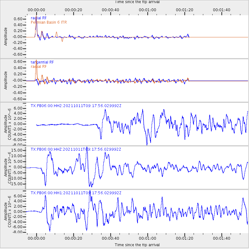
Signal To Noise
| Channel | StoN | STA | LTA |
| TX:PB06:00:HHZ:20211011T09:17:56.029992Z | 15.513356 | 4.187764E-6 | 2.699457E-7 |
| TX:PB06:00:HH1:20211011T09:17:56.029992Z | 6.698634 | 1.6073228E-6 | 2.3994784E-7 |
| TX:PB06:00:HH2:20211011T09:17:56.029992Z | 7.8360586 | 1.3347436E-6 | 1.7033355E-7 |
| Arrivals |
| Ps | 5.9 SECOND |
| PpPs | 15 SECOND |
| PsPs/PpSs | 21 SECOND |


