You are here: Home > Network List > TX - Texas Seismological Network Stations List
> Station PB19 West of Imperial > Earthquake Result Viewer
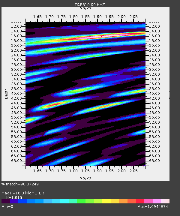
PB19 West of Imperial - Earthquake Result Viewer
| Earthquake location: |
Alaska Peninsula |
| Earthquake latitude/longitude: |
56.3/-156.6 |
| Earthquake time(UTC): |
2021/10/11 (284) 09:10:24 GMT |
| Earthquake Depth: |
69 km |
| Earthquake Magnitude: |
6.9 mww |
| Earthquake Catalog/Contributor: |
NEIC PDE/ak |
|
| Network: |
TX Texas Seismological Network |
| Station: |
PB19 West of Imperial |
| Lat/Lon: |
31.30 N/103.10 W |
| Elevation: |
782 m |
|
| Distance: |
44.5 deg |
| Az: |
101.063 deg |
| Baz: |
320.223 deg |
| Ray Param: |
0.071688585 |
| Estimated Moho Depth: |
16.0 km |
| Estimated Crust Vp/Vs: |
1.91 |
| Assumed Crust Vp: |
6.121 km/s |
| Estimated Crust Vs: |
3.196 km/s |
| Estimated Crust Poisson's Ratio: |
0.31 |
|
| Radial Match: |
90.87249 % |
| Radial Bump: |
400 |
| Transverse Match: |
81.11109 % |
| Transverse Bump: |
400 |
| SOD ConfigId: |
26497111 |
| Insert Time: |
2021-10-25 09:35:36.298 +0000 |
| GWidth: |
2.5 |
| Max Bumps: |
400 |
| Tol: |
0.001 |
|

Signal To Noise
| Channel | StoN | STA | LTA |
| TX:PB19:00:HHZ:20211011T09:17:58.645013Z | 29.477682 | 5.76518E-6 | 1.9557778E-7 |
| TX:PB19:00:HHN:20211011T09:17:58.645013Z | 6.028195 | 1.5576915E-6 | 2.5840097E-7 |
| TX:PB19:00:HHE:20211011T09:17:58.645013Z | 5.8099275 | 1.0911546E-6 | 1.8780862E-7 |
| Arrivals |
| Ps | 2.5 SECOND |
| PpPs | 7.2 SECOND |
| PsPs/PpSs | 9.7 SECOND |


