You are here: Home > Network List > TX - Texas Seismological Network Stations List
> Station PB33 CR 111 > Earthquake Result Viewer
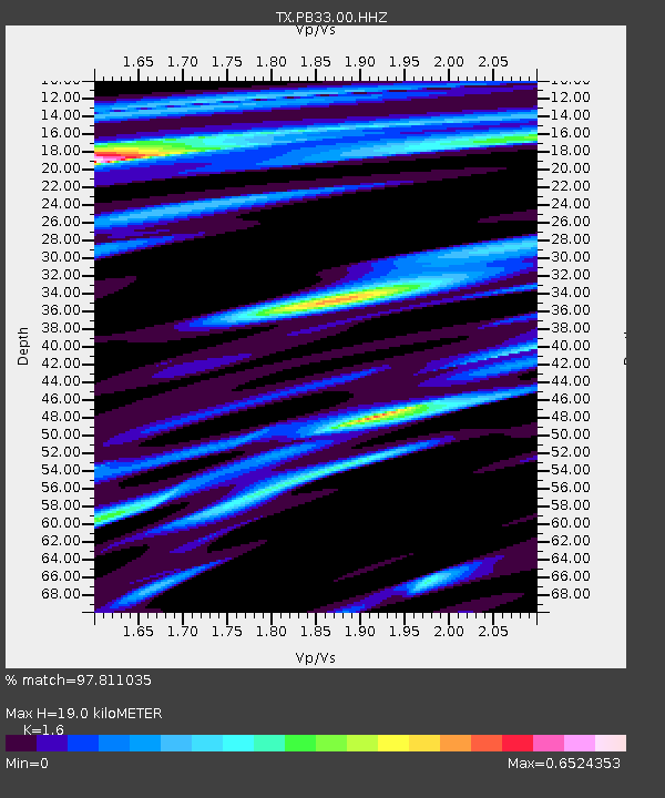
PB33 CR 111 - Earthquake Result Viewer
| Earthquake location: |
Alaska Peninsula |
| Earthquake latitude/longitude: |
56.3/-156.6 |
| Earthquake time(UTC): |
2021/10/11 (284) 09:10:24 GMT |
| Earthquake Depth: |
69 km |
| Earthquake Magnitude: |
6.9 mww |
| Earthquake Catalog/Contributor: |
NEIC PDE/ak |
|
| Network: |
TX Texas Seismological Network |
| Station: |
PB33 CR 111 |
| Lat/Lon: |
31.53 N/104.05 W |
| Elevation: |
1006 m |
|
| Distance: |
43.8 deg |
| Az: |
101.751 deg |
| Baz: |
320.221 deg |
| Ray Param: |
0.07212691 |
| Estimated Moho Depth: |
19.0 km |
| Estimated Crust Vp/Vs: |
1.60 |
| Assumed Crust Vp: |
6.361 km/s |
| Estimated Crust Vs: |
3.975 km/s |
| Estimated Crust Poisson's Ratio: |
0.18 |
|
| Radial Match: |
97.811035 % |
| Radial Bump: |
294 |
| Transverse Match: |
91.91337 % |
| Transverse Bump: |
400 |
| SOD ConfigId: |
26497111 |
| Insert Time: |
2021-10-25 09:35:42.329 +0000 |
| GWidth: |
2.5 |
| Max Bumps: |
400 |
| Tol: |
0.001 |
|

Signal To Noise
| Channel | StoN | STA | LTA |
| TX:PB33:00:HHZ:20211011T09:17:53.070Z | 8.983275 | 3.2275168E-6 | 3.592806E-7 |
| TX:PB33:00:HH1:20211011T09:17:53.070Z | 3.1799896 | 1.0172026E-6 | 3.198761E-7 |
| TX:PB33:00:HH2:20211011T09:17:53.070Z | 8.25729 | 1.2265862E-6 | 1.4854585E-7 |
| Arrivals |
| Ps | 1.9 SECOND |
| PpPs | 7.2 SECOND |
| PsPs/PpSs | 9.2 SECOND |


