You are here: Home > Network List > TX - Texas Seismological Network Stations List
> Station PH03 Pantex > Earthquake Result Viewer
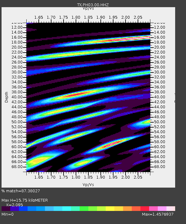
PH03 Pantex - Earthquake Result Viewer
| Earthquake location: |
Alaska Peninsula |
| Earthquake latitude/longitude: |
56.3/-156.6 |
| Earthquake time(UTC): |
2021/10/11 (284) 09:10:24 GMT |
| Earthquake Depth: |
69 km |
| Earthquake Magnitude: |
6.9 mww |
| Earthquake Catalog/Contributor: |
NEIC PDE/ak |
|
| Network: |
TX Texas Seismological Network |
| Station: |
PH03 Pantex |
| Lat/Lon: |
35.36 N/101.55 W |
| Elevation: |
1061 m |
|
| Distance: |
42.3 deg |
| Az: |
95.761 deg |
| Baz: |
317.215 deg |
| Ray Param: |
0.07305857 |
| Estimated Moho Depth: |
15.75 km |
| Estimated Crust Vp/Vs: |
2.10 |
| Assumed Crust Vp: |
6.426 km/s |
| Estimated Crust Vs: |
3.067 km/s |
| Estimated Crust Poisson's Ratio: |
0.35 |
|
| Radial Match: |
87.38027 % |
| Radial Bump: |
400 |
| Transverse Match: |
81.74313 % |
| Transverse Bump: |
400 |
| SOD ConfigId: |
26497111 |
| Insert Time: |
2021-10-25 09:35:45.425 +0000 |
| GWidth: |
2.5 |
| Max Bumps: |
400 |
| Tol: |
0.001 |
|

Signal To Noise
| Channel | StoN | STA | LTA |
| TX:PH03:00:HHZ:20211011T09:17:41.099999Z | 10.203392 | 7.2241573E-6 | 7.0801525E-7 |
| TX:PH03:00:HH1:20211011T09:17:41.099999Z | 2.7737644 | 2.5436375E-6 | 9.170345E-7 |
| TX:PH03:00:HH2:20211011T09:17:41.099999Z | 2.0769577 | 1.9690458E-6 | 9.4804335E-7 |
| Arrivals |
| Ps | 2.8 SECOND |
| PpPs | 7.2 SECOND |
| PsPs/PpSs | 10 SECOND |


