You are here: Home > Network List > TX - Texas Seismological Network Stations List
> Station RTBA Rita Blanca > Earthquake Result Viewer
RTBA Rita Blanca - Earthquake Result Viewer
| Earthquake location: |
Alaska Peninsula |
| Earthquake latitude/longitude: |
56.3/-156.6 |
| Earthquake time(UTC): |
2021/10/11 (284) 09:10:24 GMT |
| Earthquake Depth: |
69 km |
| Earthquake Magnitude: |
6.9 mww |
| Earthquake Catalog/Contributor: |
NEIC PDE/ak |
|
| Network: |
TX Texas Seismological Network |
| Station: |
RTBA Rita Blanca |
| Lat/Lon: |
36.44 N/102.74 W |
| Elevation: |
1284 m |
|
| Distance: |
40.9 deg |
| Az: |
95.709 deg |
| Baz: |
316.483 deg |
| Ray Param: |
0.07394199 |
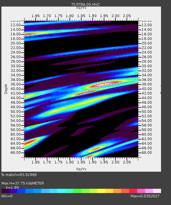
| Estimated Moho Depth: |
37.75 km |
| Estimated Crust Vp/Vs: |
1.95 |
| Assumed Crust Vp: |
6.306 km/s |
| Estimated Crust Vs: |
3.234 km/s |
| Estimated Crust Poisson's Ratio: |
0.32 |
|
| Radial Match: |
93.51988 % |
| Radial Bump: |
353 |
| Transverse Match: |
80.07691 % |
| Transverse Bump: |
360 |
| SOD ConfigId: |
26497111 |
| Insert Time: |
2021-10-25 09:35:50.737 +0000 |
| GWidth: |
2.5 |
| Max Bumps: |
400 |
| Tol: |
0.001 |
|

Signal To Noise
| Channel | StoN | STA | LTA |
| TX:RTBA:00:HHZ:20211011T09:17:29.304986Z | 32.83299 | 6.981075E-6 | 2.126238E-7 |
| TX:RTBA:00:HH1:20211011T09:17:29.304986Z | 15.001988 | 2.1122319E-6 | 1.407968E-7 |
| TX:RTBA:00:HH2:20211011T09:17:29.304986Z | 9.21341 | 2.029181E-6 | 2.2024213E-7 |
| Arrivals |
| Ps | 6.0 SECOND |
| PpPs | 17 SECOND |
| PsPs/PpSs | 23 SECOND |


