You are here: Home > Network List > TX - Texas Seismological Network Stations List
> Station SN07 Snyder 07 > Earthquake Result Viewer
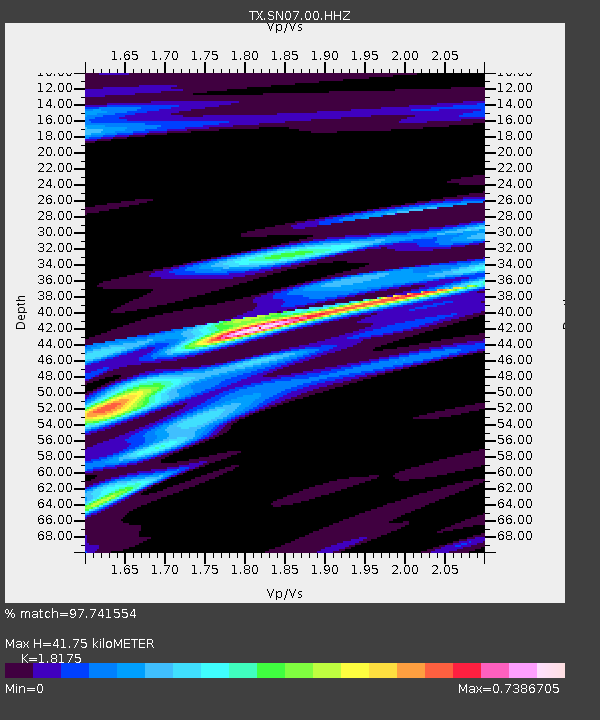
SN07 Snyder 07 - Earthquake Result Viewer
| Earthquake location: |
Alaska Peninsula |
| Earthquake latitude/longitude: |
56.3/-156.6 |
| Earthquake time(UTC): |
2021/10/11 (284) 09:10:24 GMT |
| Earthquake Depth: |
69 km |
| Earthquake Magnitude: |
6.9 mww |
| Earthquake Catalog/Contributor: |
NEIC PDE/ak |
|
| Network: |
TX Texas Seismological Network |
| Station: |
SN07 Snyder 07 |
| Lat/Lon: |
33.09 N/100.89 W |
| Elevation: |
620 m |
|
| Distance: |
44.3 deg |
| Az: |
97.375 deg |
| Baz: |
318.758 deg |
| Ray Param: |
0.07177916 |
| Estimated Moho Depth: |
41.75 km |
| Estimated Crust Vp/Vs: |
1.82 |
| Assumed Crust Vp: |
6.426 km/s |
| Estimated Crust Vs: |
3.536 km/s |
| Estimated Crust Poisson's Ratio: |
0.28 |
|
| Radial Match: |
97.741554 % |
| Radial Bump: |
223 |
| Transverse Match: |
85.79971 % |
| Transverse Bump: |
400 |
| SOD ConfigId: |
26497111 |
| Insert Time: |
2021-10-25 09:35:59.727 +0000 |
| GWidth: |
2.5 |
| Max Bumps: |
400 |
| Tol: |
0.001 |
|

Signal To Noise
| Channel | StoN | STA | LTA |
| TX:SN07:00:HHZ:20211011T09:17:57.540002Z | 41.7548 | 8.126569E-6 | 1.94626E-7 |
| TX:SN07:00:HH1:20211011T09:17:57.540002Z | 29.513298 | 3.1623808E-6 | 1.0715105E-7 |
| TX:SN07:00:HH2:20211011T09:17:57.540002Z | 18.351091 | 2.8904171E-6 | 1.5750656E-7 |
| Arrivals |
| Ps | 5.7 SECOND |
| PpPs | 17 SECOND |
| PsPs/PpSs | 23 SECOND |


